
File:Anglo.Saxon.migration.5th.cen.jpg
原始檔案 (1,800 × 1,703 像素,檔案大小:875 KB,MIME 類型:image/jpeg)

|
本圖片是以PNG、GIF或JPEG格式上傳。然而,其中包含的資料或訊息,應該重新建立成可縮放向量圖形(SVG)檔案,以更有效率或更準確的方式儲存。如有可能,請上傳本圖片的SVG格式版本。在上傳之後,請修改維基各姊妹計畫中所有使用舊版圖片的條目(列在圖像連結章節中),替換為新版圖片,並在舊圖片的描述頁中加入{{Vector version available|新圖片名稱.svg}}模板,同時移除本模板。
|


摘要
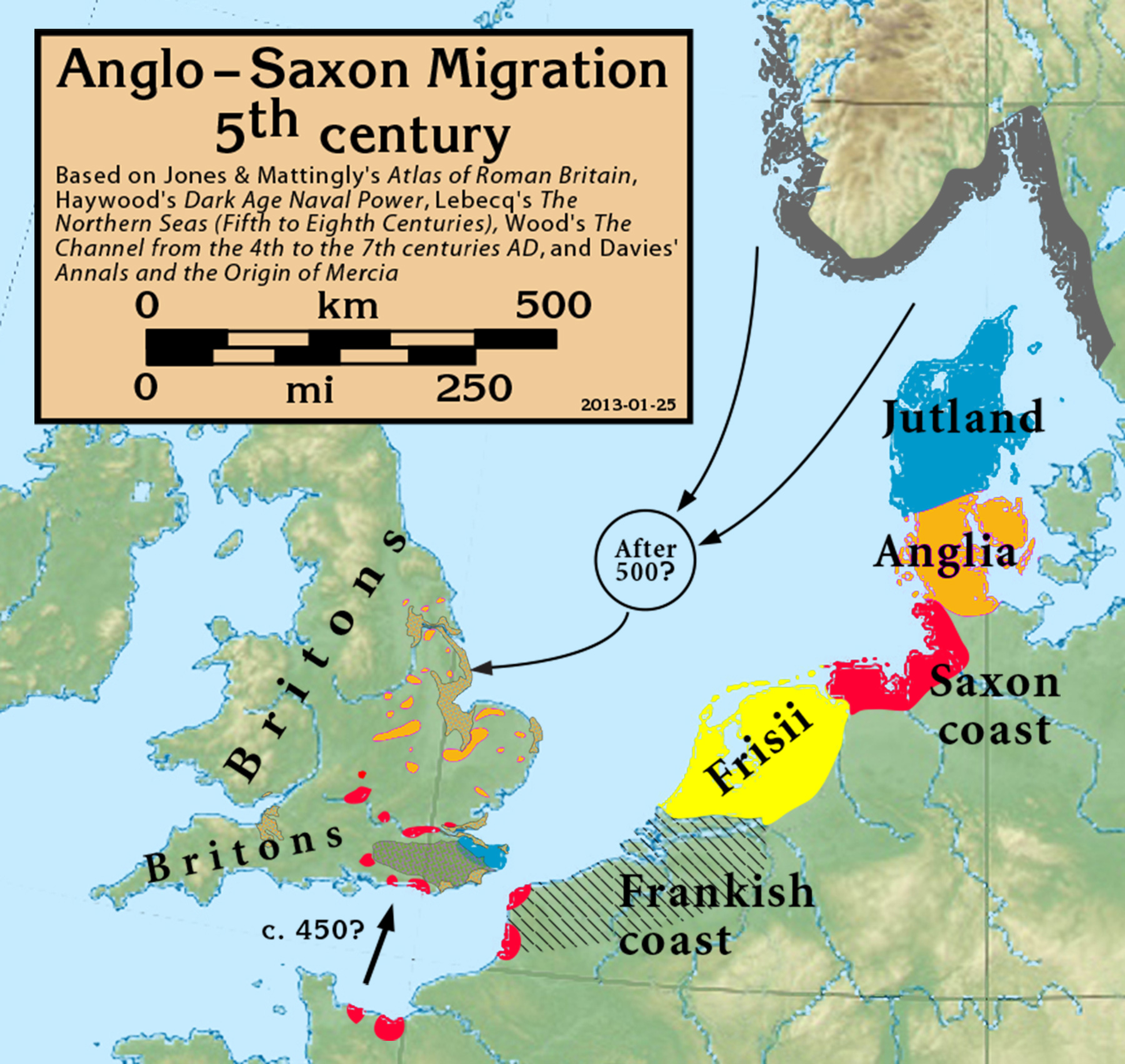
| 描述 | Anglo-Saxon Migration in the 5th century |
| 日期 | |
| 來源 |
Based on Jones & Mattingly's Atlas of Roman Britain (ISBN 978-1-84217-06700, 1990, reprinted 2007, pp. 317, 318), Haywood's Dark Age Naval Power (ISBN 1-898281-43-2, 1999, cemeteries on pp. 84–86, 121, region of "Romanisation" on p. 151), Lebecq's The Northern Seas (fifth to eighth centuries) (in The New Cambridge Medieval History, Vol I c.500–c.700, ISBN 13-978-0-521-36291-7, 2005, p. 643), and Wood's The Channel from the 4th to the 7th centuries AD in Carver's Maritime Celts, Frisians and Saxons (ISBN 978-0906780930, pp 93–97). The suggestion that settlements in Britain were made from the Bessin is from Haywood (Vron, for example, was abandoned c. 450). Jones & Mattingly also show 5th century cemeteries in the central English Midlands south of the River Trent, based on the dating of excavated cemeteries, but this is disputed by historians arguing for a 6th century Anglo-Saxon expansion into that region (see, for example Annals and the Origin of Mercia, pp. 20–24, by Wendy Davies, in Mercian Studies, 1977, ISBN 0718511484).
|
| 作者 | my work |
授權條款
- 您可以自由:
- 分享 – 複製、發佈和傳播本作品
- 重新修改 – 創作演繹作品
- 惟需遵照下列條件:
- 姓名標示 – 您必須指名出正確的製作者,和提供授權條款的連結,以及表示是否有對內容上做出變更。您可以用任何合理的方式來行動,但不得以任何方式表明授權條款是對您許可或是由您所使用。
- 相同方式分享 – 如果您利用本素材進行再混合、轉換或創作,您必須基於如同原先的相同或兼容的條款,來分布您的貢獻成品。
檔案歷史
點選日期/時間以檢視該時間的檔案版本。
| 日期/時間 | 縮圖 | 尺寸 | 用戶 | 備註 | |
|---|---|---|---|---|---|
| 目前 | 2021年9月27日 (一) 17:05 | | 1,800 × 1,703(875 KB) | GPinkerton | Reverted to version as of 16:39, 25 January 2013 (UTC) COM:CROP |
| 2020年5月19日 (二) 15:57 |  | 1,800 × 1,703(885 KB) | Claude Zygiel | Shoreline (high tide) of this time + Flevo lake (the british bank of North Sea was lower but in tectonic rise, the continental bank was upper but in subsidence) | |
| 2013年1月25日 (五) 16:39 |  | 1,800 × 1,703(875 KB) | Notuncurious | minor cleanup and improvement | |
| 2013年1月24日 (四) 20:29 |  | 2,635 × 2,451(932 KB) | Notuncurious | User created page with UploadWizard |
檔案用途
下列頁面有用到此檔案:
全域檔案使用狀況
以下其他 wiki 使用了這個檔案:
- ar.wikipedia.org 的使用狀況
- arz.wikipedia.org 的使用狀況
- azb.wikipedia.org 的使用狀況
- br.wikipedia.org 的使用狀況
- ca.wikipedia.org 的使用狀況
- cs.wikipedia.org 的使用狀況
- de.wikipedia.org 的使用狀況
- en-two.iwiki.icu 的使用狀況
- es.wikipedia.org 的使用狀況
- et.wikipedia.org 的使用狀況
- eu.wikipedia.org 的使用狀況
- fi.wikipedia.org 的使用狀況
- fr.wikipedia.org 的使用狀況
- fy.wikipedia.org 的使用狀況
- ga.wikipedia.org 的使用狀況
- he.wikipedia.org 的使用狀況
- hr.wikipedia.org 的使用狀況
- hu.wikipedia.org 的使用狀況
- hy.wikipedia.org 的使用狀況
- id.wikipedia.org 的使用狀況
- it.wikipedia.org 的使用狀況
- mk.wikipedia.org 的使用狀況
- ms.wikipedia.org 的使用狀況
- nl.wikipedia.org 的使用狀況
- pl.wikipedia.org 的使用狀況
- pt.wikipedia.org 的使用狀況
- ru.wikipedia.org 的使用狀況
- sh.wikipedia.org 的使用狀況
- simple.wikipedia.org 的使用狀況
- sk.wikipedia.org 的使用狀況
- sl.wikipedia.org 的使用狀況
- sr.wikipedia.org 的使用狀況
檢視此檔案的更多全域使用狀況。