
File:EB1 Plate LXXXVII Fig. 2 World.png

預覽大小:800 × 448 像素。 其他解析度:320 × 179 像素 | 640 × 358 像素 | 1,024 × 573 像素 | 1,280 × 717 像素 | 2,768 × 1,550 像素。
原始檔案 (2,768 × 1,550 像素,檔案大小:3.34 MB,MIME 類型:image/png)
摘要
| 描述 |
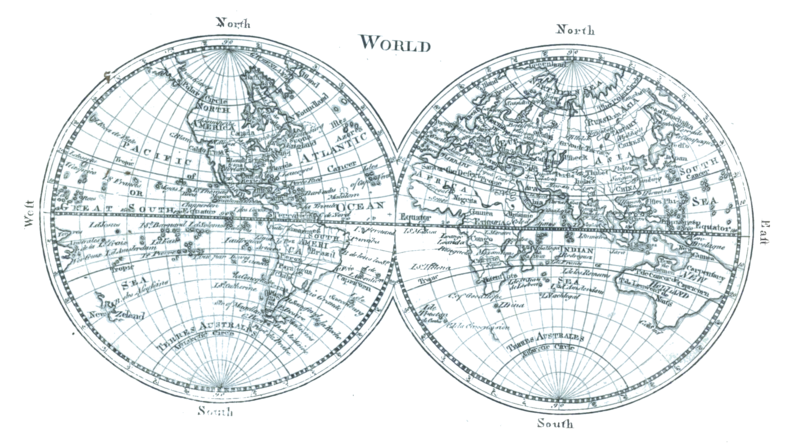
English: A map of the world as two equatorial orthographic projections of the western and eastern hemispheres as known c. 1761 from Plate LXXXVII from the Encyclopaedia Britannica, 1st ed. This map contains examples of: New Holland (Australia), Baffin Bay, Baffin Island, Cape Blanco, New Albion, Viceroyalty of New Spain, Nova Scotia, Viceroyalty of Peru, Viceroyalty of New Granada, unspecified phantom islands, Terra incognita, Saint Helena, Khoikhoi, South East Cape, Van Diemen's Land, Gulf of Carpentaria, New Britain, Nuytsland, Tartary, Veneto, Novaya Zemlya, Guinea, Sahara, Jerusalem, Arabia |
| 日期 | Drawn 1761, reprinted 1763 & 1764, edited & reengraved 1771. |
| 來源 | Encyclopaedia Britannica, 1st ed., Vol. II, p. 680 ff. Uncredited reprint of Maps 1 & 2 in the 1763 (reprinted 1764) A New General and Universal Atlas... |
| 作者 | Andrew Dury, engraved by Thomas Kitchen. Credited to Andrew Bell, engraver. |
| 其他版本 |
|


授權條款
|
本作品在其來源國以及其他版權期限是作者逝世後70年或以下的國家與地區屬於公有領域。 | |
| 此作品無已知的著作權限制,亦不受所有相關和鄰接的權利限制。 | |
| 註解 | 該圖片含有註解:在維基媒體共享資源上查看註解 |
檔案歷史
點選日期/時間以檢視該時間的檔案版本。
| 日期/時間 | 縮圖 | 尺寸 | 用戶 | 備註 | |
|---|---|---|---|---|---|
| 目前 | 2023年1月15日 (日) 20:15 | | 2,768 × 1,550(3.34 MB) | LlywelynII | Uploaded a work by Andrew Bell, engraver. from ''Encyclopaedia Britannica'', 1st ed., Vol. II, [https://archive.org/details/1771EncyclopediaBritannicaNLS/First%20edition%2C%201771%20-%20Encyclopaedia%20Britannica%3B%20or%2C%20A%20dictionary%20of%20arts%20and%20sciences%2C%20compiled%20upon%20a%20new%20plan%20%E2%80%A6%2C%20Volume%202%2C%20C-L/page/n649/mode/2up p. 680 ff.] with UploadWizard |
檔案用途
沒有使用此檔案的頁面。
全域檔案使用狀況
以下其他 wiki 使用了這個檔案:
- en.wikisource.org 的使用狀況