
File:Lithuania territory 1939-1940.svg

此 SVG 檔案的 PNG 預覽的大小:761 × 600 像素。 其他解析度:305 × 240 像素 | 609 × 480 像素 | 974 × 768 像素 | 1,280 × 1,009 像素 | 2,560 × 2,018 像素 | 2,479 × 1,954 像素。
原始檔案 (SVG 檔案,表面大小:2,479 × 1,954 像素,檔案大小:211 KB)
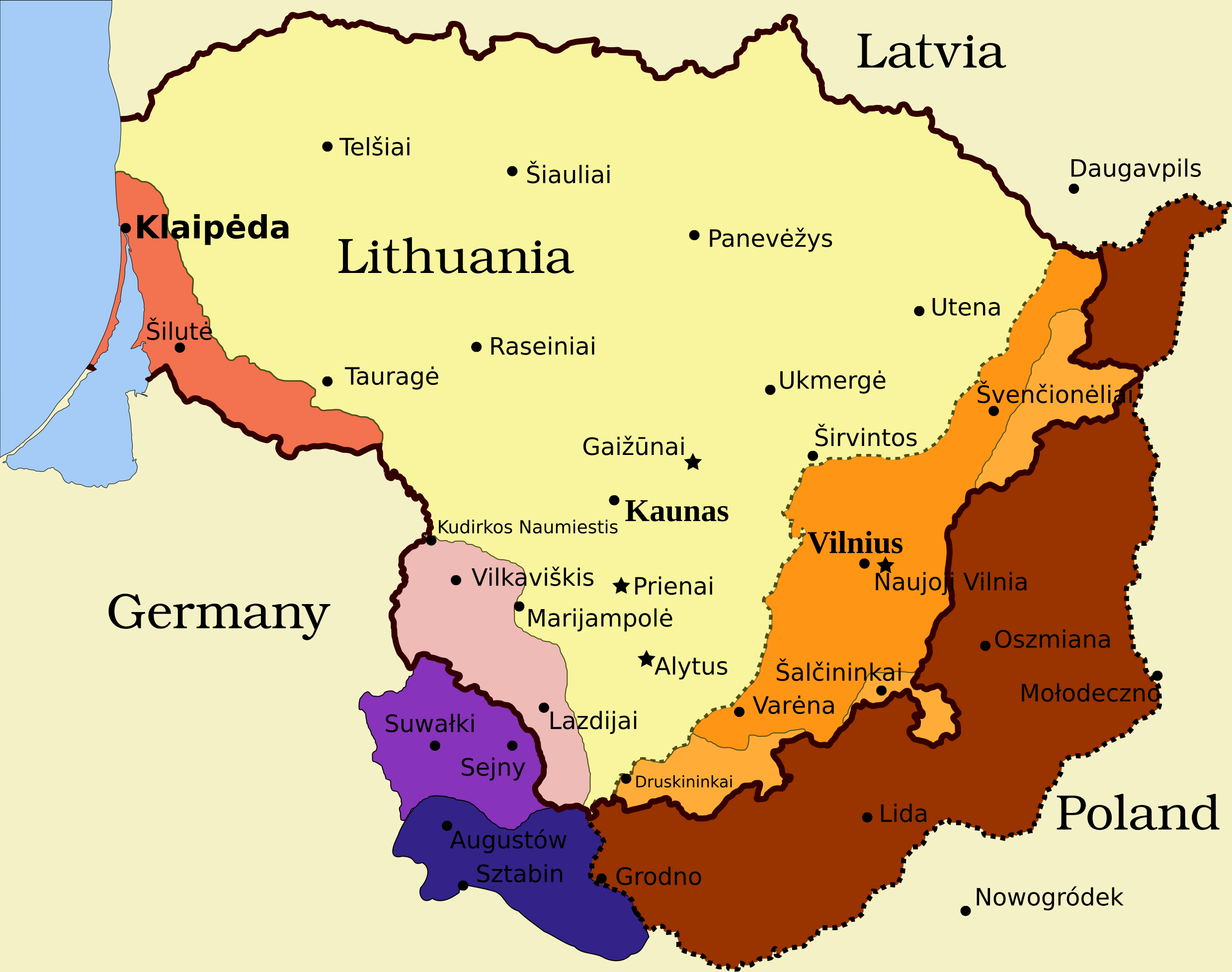
Legend
- Borders and other
Border of Lithuania (1945 – present)
Border of Vilnius Region: Polish territory; claimed by Lithuania based on the Soviet–Lithuania Peace Treaty of 1920; occupied by the Soviet Union in September 1939
![]() Soviet military bases established in Lithuania according to the Soviet–Lithuania Mutual Assistance Treaty, signed on October 10, 1939
Soviet military bases established in Lithuania according to the Soviet–Lithuania Mutual Assistance Treaty, signed on October 10, 1939
- Klaipėda Region
Klaipėda Region: detached from the German Empire by the Treaty of Versailles; placed under administration of the Entente; taken by Lithuanians during the Klaipėda Revolt in January 1923; returned to Nazi Germany after an ultimatum on March 20, 1939
- Sudovia
Territory west of the Šešupė River: Lithuanian territory; requested by Nazi Germany in the German-Soviet Boundary and Friendship Treaty on September 28, 1939; occupied by the Soviet Union on June 15, 1940; Nazi Germany relinquished its claims for a compensation in the amount of $7.5 million on January 10, 1941
"Suwałki Triangle": Polish territory; claimed by Lithuania; occupied by Nazi Germany in September 1939
Southern Suvalkai Region: Polish territory; claimed by Lithuania; occupied by the Soviet Union in September 1939
Vilnius Region
Western Vilnius Region: transferred to Lithuania based on the Soviet–Lithuania Mutual Assistance Treaty, signed on October 10, 1939
Western Vilnius Region: transferred to Lithuanian SSR on November 6, 1940
Eastern Vilnius Region: by Soviet–Lithuanian Peace Treaty assigned to Lithuania in July 12, 1920
摘要
| 描述 | Map of territorial disputes and claims regarding Lithuania in 1939-1940 |
| 日期 | |
| 來源 | Self-made using Inkscape; used Image:LithuaniaPhysicalMap-Clean.svg by Knutux for some background features; Source map: (2001) Lietuvos istorijos atlasas, Vilnius: Vaga, p. 44 & 45 |
| 作者 | |
| 授權許可 (重用此檔案) |
GFDL & all CC-BY-SA |
| 其他版本 |
[]
|


授權條款
我,本作品的著作權持有者,決定用以下授權條款發佈本作品:

|
已授權您依據自由軟體基金會發行的無固定段落、封面文字和封底文字GNU自由文件授權條款1.2版或任意後續版本,對本檔進行複製、傳播和/或修改。該協議的副本列在GNU自由文件授權條款中。 |
This file is licensed under the Creative Commons Attribution-Share Alike Attribution-Share Alike 4.0 International, 3.0 Unported, 2.5 Generic, 2.0 Generic and 1.0 Generic license.
- 您可以自由:
- 分享 – 複製、發佈和傳播本作品
- 重新修改 – 創作演繹作品
- 惟需遵照下列條件:
- 姓名標示 – 您必須指名出正確的製作者,和提供授權條款的連結,以及表示是否有對內容上做出變更。您可以用任何合理的方式來行動,但不得以任何方式表明授權條款是對您許可或是由您所使用。
- 相同方式分享 – 如果您利用本素材進行再混合、轉換或創作,您必須基於如同原先的相同或兼容的條款,來分布您的貢獻成品。
您可以選擇您需要的授權條款。
檔案歷史
點選日期/時間以檢視該時間的檔案版本。
| 日期/時間 | 縮圖 | 尺寸 | 用戶 | 備註 | |
|---|---|---|---|---|---|
| 目前 | 2024年3月27日 (三) 11:13 | | 2,479 × 1,954(211 KB) | X3SNW8 | File uploaded using svgtranslate tool (https://svgtranslate.toolforge.org/). Added translation for it. |
| 2010年8月20日 (五) 14:38 |  | 2,479 × 1,954(207 KB) | Tomasz Bladyniec | 1. There was an error in the name of one of villages. "Graizunai" should be "Gaizunai". 2. If the southeastern territory is decribed as Poland, names of cities should be in Polish then, as they were those times. 3. There's no need to write "Nazi Germany". | |
| 2008年3月30日 (日) 22:35 |  | 2,479 × 1,954(203 KB) | Renata3 | get rid of legend - too bulky in articles | |
| 2008年3月30日 (日) 21:35 |  | 3,290 × 1,954(226 KB) | Fvasconcellos | layers | |
| 2008年3月29日 (六) 14:22 |  | 3,290 × 1,954(223 KB) | Fvasconcellos | font fixes | |
| 2008年3月29日 (六) 14:10 |  | 3,290 × 1,954(210 KB) | Fvasconcellos | one more attempt | |
| 2008年3月28日 (五) 16:58 |  | 3,290 × 1,954(226 KB) | Mangwanani | tried to fix image | |
| 2008年3月28日 (五) 16:28 |  | 3,290 × 1,954(226 KB) | Renata3 | {{Information |Description=Map of territorial disputes and claims regarding Lithuania in 1939-1940 |Source=Self-made using Inkscape; used Image:LithuaniaPhysicalMap-Clean.svg by Knutux for some background features; Source map: (2001) ''Lietuvos istor |
檔案用途
下列3個頁面有用到此檔案:
全域檔案使用狀況
以下其他 wiki 使用了這個檔案:
- ar.wikipedia.org 的使用狀況
- az.wikipedia.org 的使用狀況
- be-tarask.wikipedia.org 的使用狀況
- be.wikipedia.org 的使用狀況
- bg.wikipedia.org 的使用狀況
- bn.wikipedia.org 的使用狀況
- ca.wikipedia.org 的使用狀況
- cs.wikipedia.org 的使用狀況
- el.wikipedia.org 的使用狀況
- en-two.iwiki.icu 的使用狀況
- History of Lithuania
- Molotov–Ribbentrop Pact
- Vilnius Region
- Portal:Lithuania
- Talk:Sejny Uprising
- 1938 Polish ultimatum to Lithuania
- Wikipedia:Graphics Lab/Images to improve/Archive/Apr 2008
- Wikipedia:Articles for deletion/Log/2008 April 18
- Wikipedia:Articles for deletion/Suvalkai Region
- Soviet–Lithuanian Mutual Assistance Treaty
- German–Soviet Border and Commercial Agreement
- German occupation of Lithuania during World War II
- Soviet ultimatum to Lithuania
- Talk:Sejny Uprising/GA1
- Talk:The Holocaust in Poland/Archives/2018/April
- User:Artemis Andromeda/sandbox/Republic of Lithuania (1918–1940)
- User:Falcaorib/Poland-Lithuania
- es.wikipedia.org 的使用狀況
- et.wikipedia.org 的使用狀況
- fa.wikipedia.org 的使用狀況
- fi.wikipedia.org 的使用狀況
- fr.wikipedia.org 的使用狀況
- hy.wikipedia.org 的使用狀況
- id.wikipedia.org 的使用狀況
檢視此檔案的更多全域使用狀況。