
File:Mao Kun map - Singapore.png

預覽大小:799 × 344 像素。 其他解析度:320 × 138 像素 | 640 × 276 像素 | 1,289 × 555 像素。
原始檔案 (1,289 × 555 像素,檔案大小:473 KB,MIME 類型:image/png)
摘要
| 描述 |
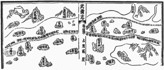
English: A Mao Kun map showing Singapore and part of the east coast of the Malay peninsula. Temasek (early Singapore; " 淡馬錫 ) is marked at the top left corner, others identified by Wheatley are Pulau Brani (琵琶嶼), Blakang Mati (長腰嶼, Sentosa), Pedra Branca (白礁), Pulau Tinggi (將軍帽), Pulau Aur (東竹山 and 西竹山), Pahang River estuary (彭杭港), and Pulau Tioman (苧麻山). Long Ya Men (龍牙門) on the map is said to mark the entrance to Keppel Harbour. Note that different sources may identify the islands differently, especially the islands of Singapore. J. V. G. Mills for example identified 長腰嶼 as Pulau Satumu and 琵琶嶼 as Pulau Sakijang Pelepah. |
| 日期 | 17世紀 |
| 來源 | Scanned from Paul Wheatley (1961年) 《 The Golden Khersonese: Studies in the Historical Geography of the Malay Peninsula before A.D. 1500》、吉隆坡: University of Malaya Press OCLC: 504030596. Originally from the Wubei Zhi (Treatise on Armament Technology), a 17th century work with maps based on material dated to the voyages of Zheng He (early 15th century). |
| 作者 | Mao Yuanyi (1594–1640?), editor of the Wubei Zhi; and an unknown cartographer. |
授權條款
|
此為如實地拍攝平面藝術品的相片複製本。原作位於公有領域,是因下列原因:
維基媒體基金會的官方立場認為:「針對平面公有領域的藝術作品進行忠實重製,其重製後的照片也屬於公有領域。」
因此,可認定本重製照片屬於公有領域。在其他司法管轄區,再利用此照片可能會被限制;參見再利用PD-Art照片以獲得進一步資訊。 | ||||
檔案歷史
點選日期/時間以檢視該時間的檔案版本。
| 日期/時間 | 縮圖 | 尺寸 | 用戶 | 備註 | |
|---|---|---|---|---|---|
| 目前 | 2015年7月30日 (四) 14:42 | | 1,289 × 555(473 KB) | Hzh | User created page with UploadWizard |
檔案用途
下列頁面有用到此檔案:
全域檔案使用狀況
以下其他 wiki 使用了這個檔案:
- cs.wikipedia.org 的使用狀況
- en-two.iwiki.icu 的使用狀況
- id.wikipedia.org 的使用狀況
- it.wikipedia.org 的使用狀況
- ko.wikipedia.org 的使用狀況
- ms.wikipedia.org 的使用狀況
- ru.wikipedia.org 的使用狀況
- ta.wikipedia.org 的使用狀況
- th.wikipedia.org 的使用狀況
- tl.wikipedia.org 的使用狀況
- uk.wikipedia.org 的使用狀況