
File:MarsCuriosityRover-TracksAfterCrossing-DingoGapSandDune-20140206.jpg

原始檔案 (1,024 × 1,024 像素,檔案大小:325 KB,MIME 類型:image/jpeg)
摘要
| 描述 |
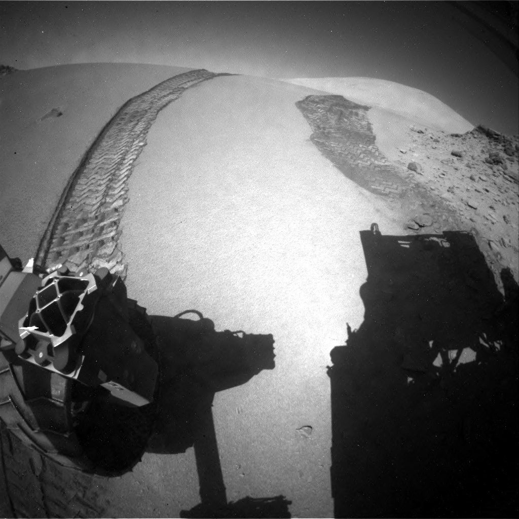
English: This image was taken by Rear Hazcam: Left B (RHAZ_LEFT_B) onboard NASA's Mars rover Curiosity on Sol 535 (2014-02-06 20:41:42 UTC).
http://mars.jpl.nasa.gov/msl/multimedia/raw/?rawid=RLB_444990726EDR_F0260366RHAZ00313M_&s=535
http://www.jpl.nasa.gov/news/news.php?release=2014-035 This view combines several frames taken by the Mast Camera (Mastcam) on NASA's Mars rover Curiosity, looking into a valley to the west from the eastern side of a dune at the eastern end of the valley.
NASA's Curiosity Mars Rover has crossed a dune that stands across a gateway to a southwestward route favored by the rover team for driving to future science destinations. After reaching the west side of the 3-foot-tall (1-meter-tall) dune today, the rover looked back at its tracks down the western slope. A raw image of the rover's tracks over the dune is at: The dune sits between low scarps at a site called "Dingo Gap" inside Mars' Gale Crater. Now that Curiosity has passed through the gap, engineers and scientists plan to direct the mobile laboratory toward a location of interest where different rock types intersect. That is a candidate site for next use of the rover's drill. Beyond that, the drive will continue toward the mission's long-term science destination on lower slopes of Mount Sharp, in the middle of the crater.
The team operating NASA's Curiosity Mars rover will likely drive the rover westward over a dune and across a valley with fewer sharp rock hazards than alternative routes. A final decision on whether to pass through this valley will ride on evaluation of a short drive planned this week toward the top of the dune that lies across "Dingo Gap." The dune is about 3 feet (1 meter) high at its center, tapered off at both sides of the gap between two low scarps. A color view assembled from images taken by Curiosity's Mast Camera (Mastcam) on the east side of the dune shows details of the valley that the rover may traverse this month. NASA's Mars Science Laboratory Project is using Curiosity to assess ancient habitable environments and major changes in Martian environmental conditions. JPL, a division of the California Institute of Technology in Pasadena, built the rover and manages the project for NASA's Science Mission Directorate in Washington. For more information about Curiosity, visit http://www.jpl.nasa.gov/msl , http://www.nasa.gov/msl and http://mars.jpl.nasa.gov/msl/. You can follow the mission on Facebook at http://www.facebook.com/marscuriosity and on Twitter at: https://twitter.com/marscuriosity. Guy Webster 818-354-6278 Jet Propulsion Laboratory, Pasadena, Calif. [email protected]Polski: Jedno z dziewięciu zdjęć wchodzących w skład animacji prezentującej widok z łazika Curiosity przekraczającego wydmę
Zdjęcia tworzące film były wykonane przez tylną kamerę Hazcam znajdującą się na należącym do NASA łaziku Curiosity podczas gdy tenże łazik przekraczał wydmę "Dingo Gap" na Marsie. Kamera Hazcam jest zamontowana nisko na podwoziu łazika i posiada szerokątny obiektyw. Curiosity przejechał ten etap (7 metrów), podczas 535 marsjańskiego dnia, lub sol, jego misji na Marsie (6 luty 2014). Na starcie łazika do etapu, prawe przednie koło znajdowało się na szczycie wysokiej na 1 metr wydmy, z łazikiem skierowanym w górę. Podczas wykonywania trzech ostatnich zdjęć serii, łazik był skierowany w dół. Lekko stonowane wzniesienie znajdujące po prawej stronie na horyzoncie jest częścią góry Mount Sharp. Obecny etap jest skierowany na zachód. Przewidywany cel łazika w dłuższym terminie to dolne stoki Mount Sharp, które znajdują się na południowy wschód od aktualnej pozycji łazika. "Dingo Gap" umożliwia przejście do doliny znajdującej się na zachodzie. Dolina ta, została zakceptowana przez zespół łazika jako trasa przejazdu posiadająca mniej ostrych skał niż inne rozważane trasy. Należące do NASA Jet Propulsion Laboratory, będące oddziałem California Institute of Technology w Pasadenie, kieruje projektem Mars Science Laboratory dla należącego do NASA Science Mission Directorate w Waszygtonie. JPL zaprojektowało i zbudowało łazik Curiosity. Malin Space Science Systems z San Diego, zbudowało i steruje kamerami masztowymi łazika (ang. Mastcams). Polska wersja opisu zdjęcia powstała na podstawie artykułu PIA17938: Movie of Curiosity's View Backwards While Crossing Dune |
| 日期 | |
| 來源 | http://mars.jpl.nasa.gov/msl-raw-images/proj/msl/redops/ods/surface/sol/00535/opgs/edr/rcam/RLB_444990726EDR_F0260366RHAZ00313M_.JPG |
| 作者 | NASA/JPL-Caltech |
授權條款
| 本作品由NASA創作,屬於公有領域。根據NASA的版權政策:“NASA的創作除非另有聲明否則不受版權保護。”(參見:Template:PD-USGov/zh,NASA版權政策或JPL圖像使用政策) | ||
 |
警告:
|
檔案歷史
點選日期/時間以檢視該時間的檔案版本。
| 日期/時間 | 縮圖 | 尺寸 | 用戶 | 備註 | |
|---|---|---|---|---|---|
| 目前 | 2014年2月8日 (六) 15:57 | | 1,024 × 1,024(325 KB) | Drbogdan | User created page with UploadWizard |
檔案用途
沒有使用此檔案的頁面。
全域檔案使用狀況
以下其他 wiki 使用了這個檔案:
- pl.wikipedia.org 的使用狀況