
File:Official New York City Subway Map 2013 vc.jpg

預覽大小:492 × 599 像素。 其他解析度:197 × 240 像素 | 394 × 480 像素 | 631 × 768 像素 | 841 × 1,024 像素 | 1,419 × 1,728 像素。
原始檔案 (1,419 × 1,728 像素,檔案大小:1.03 MB,MIME 類型:image/jpeg)
摘要
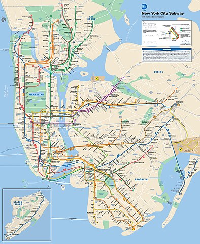
| 描述 | This is the official map of the New York City Subway as of June 2013 and produced by the Metropolitan Transportation Authority of the State of New York. |
| 日期 | |
| 來源 |
Official New York City Subway Map
|
| 作者 | Metropolitan Transportation Authority of the State of New York |
授權條款
此檔案採用創用CC 姓名標示 2.0 通用版授權條款。
- 您可以自由:
- 分享 – 複製、發佈和傳播本作品
- 重新修改 – 創作演繹作品
- 惟需遵照下列條件:
- 姓名標示 – 您必須指名出正確的製作者,和提供授權條款的連結,以及表示是否有對內容上做出變更。您可以用任何合理的方式來行動,但不得以任何方式表明授權條款是對您許可或是由您所使用。

|
本作品含有在一個或多個司法管轄區内受商標法保護的內容。任意使用以致於侵害到商標擁有者的權益將可能會面臨刑事責任與民事賠償。請使用者使用前自行查明相關法律規定並承擔一切風險與責任。參見我們的免責聲明。使用本商標並不表示由維基共享資源或維基媒體基金會對持有人的背書,反之亦然。 此標籤不表示文件的著作權狀態。任何文件在附有此標籤的同時還需要一個有效的著作權標籤。請參閱許可協議說明頁面以了解更多資訊。 |
| This image, originally posted to Flickr, was reviewed on 11 June 2013 by the administrator or reviewer File Upload Bot (Magnus Manske), who confirmed that it was available on Flickr under the stated license on that date. |
檔案歷史
點選日期/時間以檢視該時間的檔案版本。
| 日期/時間 | 縮圖 | 尺寸 | 用戶 | 備註 | |
|---|---|---|---|---|---|
| 目前 | 2020年11月27日 (五) 20:56 | | 1,419 × 1,728(1.03 MB) | Pi.1415926535 | Reverted to version as of 18:22, 11 June 2013 (UTC) per Commons:Deletion requests/File:Official New York City Subway Map vc.jpg |
| 2019年11月6日 (三) 02:48 |  | 2,700 × 3,314(5.34 MB) | Ɱ | One station opened (WTC Cortlandt) | |
| 2019年10月28日 (一) 14:04 |  | 6,003 × 7,258(9.71 MB) | Ɱ | Did you not read what I wrote? This is not a significant enough derivative to be in copyright. | |
| 2019年10月28日 (一) 07:15 |  | 1,419 × 1,728(1.03 MB) | Vcohen | Reverted to version as of 21:16, 4 January 2017 (UTC) the license is for the 2013 version | |
| 2019年10月28日 (一) 04:33 |  | 6,003 × 7,258(9.71 MB) | Ɱ | somehow lost resolution | |
| 2019年10月28日 (一) 04:30 |  | 6,003 × 7,258(9.71 MB) | Ɱ | Not significant enough expressive changes to qualify as a derivative work of the 2013 copy, only minor alterations. | |
| 2017年1月4日 (三) 21:16 |  | 1,419 × 1,728(1.03 MB) | Vcohen | the new version does not match the source and license | |
| 2017年1月2日 (一) 05:10 |  | 2,001 × 2,419(1.32 MB) | Cbuccella | Official MTA subway map as of 2017.01.01. Includes Hudson Yards station and Q Line extension. | |
| 2013年6月11日 (二) 18:22 |  | 1,419 × 1,728(1.03 MB) | File Upload Bot (Magnus Manske) | Transferred from Flickr by User:vcohen using flickr2commons |
檔案用途
全域檔案使用狀況
以下其他 wiki 使用了這個檔案:
- az.wikipedia.org 的使用狀況
- be.wikipedia.org 的使用狀況
- de.wikipedia.org 的使用狀況
- en-two.iwiki.icu 的使用狀況
- he.wikipedia.org 的使用狀況
- hr.wikipedia.org 的使用狀況
- id.wikipedia.org 的使用狀況
- it.wikipedia.org 的使用狀況
- ja-two.iwiki.icu 的使用狀況
- ko.wikipedia.org 的使用狀況
- ru.wikipedia.org 的使用狀況
- tl.wikipedia.org 的使用狀況
- tr.wikipedia.org 的使用狀況
- uk.wikipedia.org 的使用狀況
- www.wikidata.org 的使用狀況