
File:PIA16154 fig1-Mars Curiosity Rover - Road To Glenelg.jpg

原始檔案 (1,280 × 363 像素,檔案大小:671 KB,MIME 類型:image/jpeg)
摘要
| 描述 |
English: PIA16154: On the Road to Glenelg (Annotated)
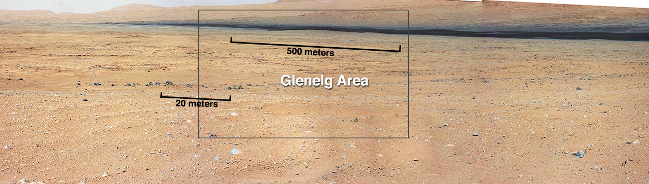
This mosaic from the Mast Camera on NASA's Curiosity rover shows the view looking toward the "Glenelg" area, where three different terrain types come together. All three types are observed from orbit with the High-Resolution Imaging Science Experiment (HiRISE) camera on NASA's Mars Reconnaissance Orbiter. By driving there, Curiosity will be able to explore them. One of the three terrain types is light-toned with well-developed layering, which likely records deposits of sedimentary materials. There are also black bands that run through the area and might constitute additional layers that alternate with the light-toned layers. The black bands are not easily seen from orbit and are on the order of about 3.3-feet (1-meter) thick. Both of these layer types are important science targets. This mosaic is composed of seven images. The Mastcam 34-millimeter camera took a series of four images; embedded within that series is a second set of three images taken with the Mastcam 100-millimeter camera. |
| 日期 | |
| 來源 | http://photojournal.jpl.nasa.gov/figures/PIA16154_fig1.jpg |
| 作者 | NASA/JPL-Caltech/MSSS |
| 其他版本 | http://photojournal.jpl.nasa.gov/catalog/PIA16154 |
授權條款
| 本作品由NASA創作,屬於公有領域。根據NASA的版權政策:“NASA的創作除非另有聲明否則不受版權保護。”(參見:Template:PD-USGov/zh,NASA版權政策或JPL圖像使用政策) | ||
 |
警告:
|
檔案歷史
點選日期/時間以檢視該時間的檔案版本。
| 日期/時間 | 縮圖 | 尺寸 | 用戶 | 備註 | |
|---|---|---|---|---|---|
| 目前 | 2012年9月20日 (四) 01:40 | 1,280 × 363(671 KB) | Drbogdan | User created page with UploadWizard |
檔案用途
下列3個頁面有用到此檔案:
全域檔案使用狀況
以下其他 wiki 使用了這個檔案:
- bn.wikipedia.org 的使用狀況
- de.wikipedia.org 的使用狀況
- en-two.iwiki.icu 的使用狀況
- fa.wikipedia.org 的使用狀況
- ja-two.iwiki.icu 的使用狀況
- kk.wikipedia.org 的使用狀況
- ko.wikipedia.org 的使用狀況
- lb.wikipedia.org 的使用狀況
- ru.wikipedia.org 的使用狀況
- test.wikipedia.org 的使用狀況
- uk.wikipedia.org 的使用狀況
- vi.wikipedia.org 的使用狀況