
File:South Luconia Shoals f 12.jpg

預覽大小:800 × 453 像素。 其他解析度:320 × 181 像素 | 640 × 362 像素 | 1,000 × 566 像素。
原始檔案 (1,000 × 566 像素,檔案大小:187 KB,MIME 類型:image/jpeg)
摘要
| 描述 |
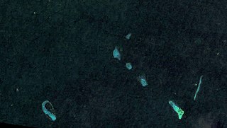
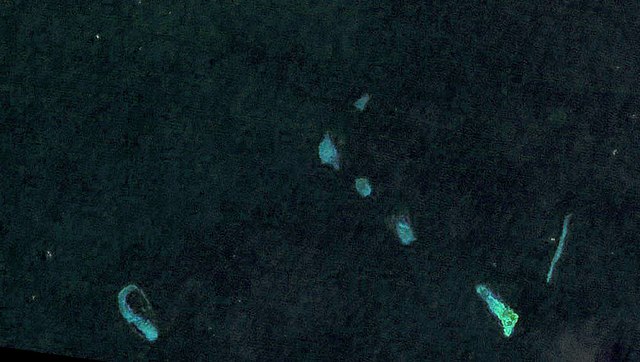
Deutsch: Landsat 7 Satellitenbild der südlichen Luconia-Untiefen (auch -Riffe, englisch South Luconia Shoals) im Südchinesische Meer südwestlich der Spratly-Inseln auf dem Festlandsockel vor dem malaysischen Bundesstaat Sarawak. Die Belichtung des Bilds wurde um ca. 12 Blendenstufen angehoben. Die Originalfarbe (RGB: 52,29,61) spielt ins Violette, daher wurde eine Farbüberlagerung (RGB:6,36,47) verwendet auf Basis der Farbe des Satelliten-Bilds von Bing Maps für diese Koordinaten 5°36′0.0″N 112°36′0.0″W / 5.6°N 112.6°W. English: Landsat 7 satellite image of the South Luconia Shoals in the South China Sea southwest of the Spratly Islands on the continental shelf in front of the Malaysian state of Sarawak. The exposure of the image has been increased by about 12 f-stops. The original color (RGB: 52,29,61) is purplish, therefore a color overlay was used which is based on the color (RGB:6,36,47) of the Satellite Image of Bing Maps for this coordinates 5°36′0.0″N 112°36′0.0″W / 5.6°N 112.6°W. |
| 日期 | |
| 來源 | https://web.archive.org/web/20120724041608/http://www.oceandots.com/pacific/luconia/ |
| 作者 | NASA |
授權條款
| 本作品由NASA創作,屬於公有領域。根據NASA的版權政策:“NASA的創作除非另有聲明否則不受版權保護。”(參見:Template:PD-USGov/zh,NASA版權政策或JPL圖像使用政策) | ||
 |
警告:
|
| 註解 | 該圖片含有註解:在維基媒體共享資源上查看註解 |
檔案歷史
點選日期/時間以檢視該時間的檔案版本。
| 日期/時間 | 縮圖 | 尺寸 | 用戶 | 備註 | |
|---|---|---|---|---|---|
| 目前 | 2015年5月18日 (一) 17:09 | | 1,000 × 566(187 KB) | MagentaGreen | =={{int:filedesc}}== {{Information |description={{de|1=Landsat 7 Satellitenbild der südlichen Luconia-Untiefen (auch -Riffe, englisch South Luconia Shoals) im Südchinesische Meer südwestlich der Spratly-Inseln auf dem Festlandsockel vor dem malaysis... |
檔案用途
下列頁面有用到此檔案:
全域檔案使用狀況
以下其他 wiki 使用了這個檔案:
- de.wikipedia.org 的使用狀況
- en-two.iwiki.icu 的使用狀況
- ja-two.iwiki.icu 的使用狀況
- ms.wikipedia.org 的使用狀況