
File:Surface-to-Air Missile Coverage over the Taiwan Strait.png
預覽大小:588 × 600 像素。 其他解析度:235 × 240 像素 | 470 × 480 像素 | 738 × 753 像素。
原始檔案 (738 × 753 像素,檔案大小:104 KB,MIME 類型:image/png)

|
本圖片是以PNG、GIF或JPEG格式上傳。然而,其中包含的資料或訊息,應該重新建立成可縮放向量圖形(SVG)檔案,以更有效率或更準確的方式儲存。如有可能,請上傳本圖片的SVG格式版本。在上傳之後,請修改維基各姊妹計畫中所有使用舊版圖片的條目(列在圖像連結章節中),替換為新版圖片,並在舊圖片的描述頁中加入{{Vector version available|新圖片名稱.svg}}模板,同時移除本模板。
|
| 描述 |
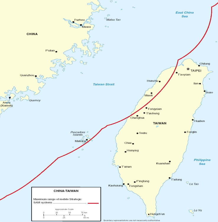
Figure 7. Surface-to-Air Missile Coverage over the Taiwan Strait. Note: This map depicts notional coverage provided by China’s SA-10, SA-20 SAM systems, as well as the soon-to-be acquired S-300PMU2. Actual coverage would be non-contiguous and dependent upon precise deployment sites. |
|||
| 日期 | 05/23/06 | |||
| 來源 | Image:China Report 2006.pdf | |||
| 作者 | DoD | |||
| 授權許可 (重用此檔案) |
|
|||
| 其他版本 | Derivative works of this file: Surface-to-Air Missile Coverage over the Taiwan Strait-ar.png |

檔案歷史
點選日期/時間以檢視該時間的檔案版本。
| 日期/時間 | 縮圖 | 尺寸 | 用戶 | 備註 | |
|---|---|---|---|---|---|
| 目前 | 2018年3月8日 (四) 22:15 | | 738 × 753(104 KB) | Ras67 | new extracted, cleaned and cropped from PDF |
| 2006年5月26日 (五) 08:40 |  | 769 × 773(256 KB) | Shizhao | {{Information |Description=Figure 7. Surface-to-Air Missile Coverage over the Taiwan Strait. Note: This map depicts notional coverage provided by China’s SA-10, SA-20 SAM systems, as well as the soon-to-be acquired S-300PMU2. Actual coverage would be n |
檔案用途
下列2個頁面有用到此檔案:
全域檔案使用狀況
以下其他 wiki 使用了這個檔案:
- en-two.iwiki.icu 的使用狀況
- es.wikipedia.org 的使用狀況
- hu.wikipedia.org 的使用狀況
- ja-two.iwiki.icu 的使用狀況
- ko.wikipedia.org 的使用狀況
- nov.wikipedia.org 的使用狀況
- pt.wikipedia.org 的使用狀況
- vi.wikipedia.org 的使用狀況
- zh-yue.wikipedia.org 的使用狀況