
File:Tropical Cyclone Wati 2006.jpg

預覽大小:799 × 599 像素。 其他解析度:320 × 240 像素 | 640 × 480 像素 | 1,024 × 768 像素 | 1,280 × 960 像素 | 2,560 × 1,920 像素 | 8,909 × 6,682 像素。
原始檔案 (8,909 × 6,682 像素,檔案大小:6.19 MB,MIME 類型:image/jpeg)
| 警告 | 部分瀏覽器在瀏覽此圖片的完整大小時可能會遇到困難:該圖片中有數量巨大的像素點,可能無法完全載入或者導致您的瀏覽器停止回應。 |
|---|
摘要
| 描述 |
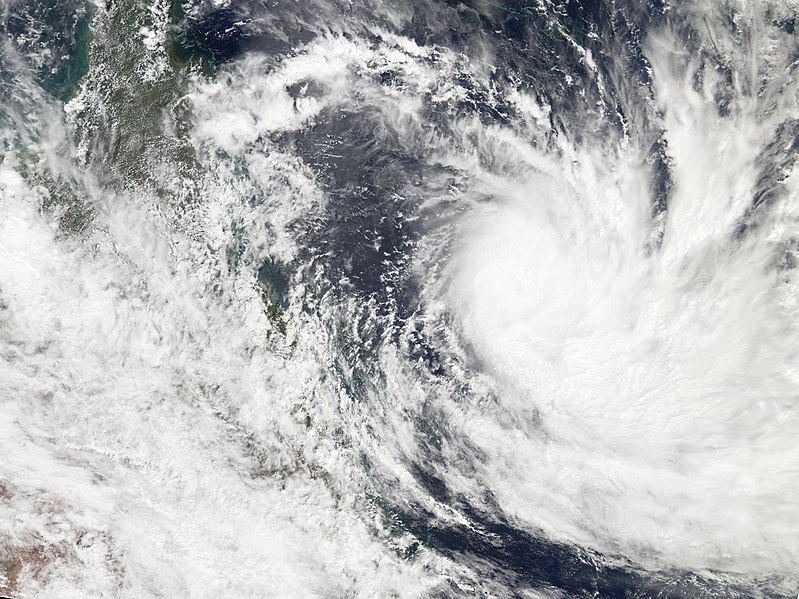
Tropical Cyclone Wati formed northeast of New Caledonia on March 19, 2006. The cyclone gained power gradually and had been heading towards the coast of Australia along a track similar to the very destructive Cyclone Larry, which came ashore in Queensland at the same time Wati was building power. However, forecasts as of March 22 projected that while Wati would continue to gain strength, it would turn sharply south and east, staying well away from the Australian mainland and New Calendonia. When the Moderate Resolution Imaging Spectroradiometer (MODIS) on the Aqua satellite observed the storm at 3:05 p.m. Australian Eastern Daylight Savings Time (04:05 UTC) on March 21, 2006, Tropical Cyclone Wati was continuing to slowly build power and size. When MODIS made this observation, the storm had peak winds of around 150 kilometers per hour (90 miles per hour), and forecasts at the time called for it to continue to gather power for at least another day. It was predicted to slowly weaken as it headed south and traveled over cooler water. In this image, the scattered and unorganized remnants of Tropical Cyclone Larry can still be seen over Queensland, well east of Cyclone Wati. |
|||||
| 日期 | ||||||
| 來源 | http://earthobservatory.nasa.gov/NaturalHazards/natural_hazards_v2.php3?img_id=13437 | |||||
| 作者 | NASA image created by Jesse Allen, Earth Observatory, using data obtained courtesy of the MODIS Rapid Response team. | |||||
| 授權許可 (重用此檔案) |
|

檔案歷史
點選日期/時間以檢視該時間的檔案版本。
| 日期/時間 | 縮圖 | 尺寸 | 用戶 | 備註 | |
|---|---|---|---|---|---|
| 目前 | 2006年9月2日 (六) 22:40 | | 8,909 × 6,682(6.19 MB) | Good kitty | == Summary == {{Information |Description=Tropical Cyclone Wati formed northeast of New Caledonia on March 19, 2006. The cyclone gained power gradually and had been heading towards the coast of Australia along a track similar to the very destructive Cyclon |
檔案用途
下列頁面有用到此檔案:
全域檔案使用狀況
以下其他 wiki 使用了這個檔案:
- en-two.iwiki.icu 的使用狀況
- pt.wikipedia.org 的使用狀況