
File:Tropical cyclone kate (2006).jpg

預覽大小:600 × 600 像素。 其他解析度:240 × 240 像素 | 480 × 480 像素 | 768 × 768 像素 | 1,024 × 1,024 像素 | 2,048 × 2,048 像素 | 4,000 × 4,000 像素。
原始檔案 (4,000 × 4,000 像素,檔案大小:2.34 MB,MIME 類型:image/jpeg)
摘要
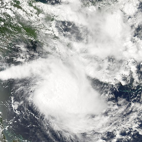
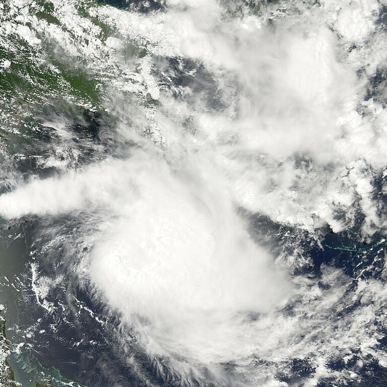
| 描述 | Tropical Cyclone Kate swirls in the Torres Strait between Australia’s Cape York Peninsula and the island of New Guinea in this satellite view of the storm, obtained by the Moderate Resolution Imaging Spectroradiometer (MODIS) instrument on NASA’s Aqua satellite on February 23, 2006. Kate was the second tropical cyclone in 2006 to form off the coast of Queensland. It was not a particularly powerful system when MODIS obtained this view, with peak winds around 80 kilometers per hour (50 miles per hour). However, because it was located so far offshore, there was little observed data from ground stations and radar instruments, which was making predictions of the storm’s path and future intensity a challenge, according to the Tropical Cyclone Warning Centre. | |||||
| 日期 | ||||||
| 來源 | http://earthobservatory.nasa.gov/NaturalHazards/natural_hazards_v2.php3?img_id=13379 | |||||
| 作者 | NASA image created by Jesse Allen, Earth Observatory, using data obtained courtesy of the MODIS Rapid Response team. | |||||
| 授權許可 (重用此檔案) |
|

.jpg?uselang=zh-mo)
.jpg?uselang=zh-mo)
.jpg?action=history&uselang=zh-mo)
.jpg)
檔案歷史
點選日期/時間以檢視該時間的檔案版本。
| 日期/時間 | 縮圖 | 尺寸 | 用戶 | 備註 | |
|---|---|---|---|---|---|
| 目前 | 2006年8月28日 (一) 23:57 | | 4,000 × 4,000(2.34 MB) | Good kitty | |
| 2006年2月28日 (二) 17:58 |  | 540 × 540(98 KB) | Miss Madeline~commonswiki | From [http://earthobservatory.nasa.gov/NaturalHazards/natural_hazards_v2.php3?img_id=13379 NASA Earth Observatory and MODIS Rapid Response Team]. 2006'2 Tropical Cyclone Kate on February 23. Category:Southern Hemisphere tropical cyclones[[category:t |
檔案用途
下列頁面有用到此檔案:
全域檔案使用狀況
以下其他 wiki 使用了這個檔案:
- en-two.iwiki.icu 的使用狀況
- pt.wikipedia.org 的使用狀況
.jpg)