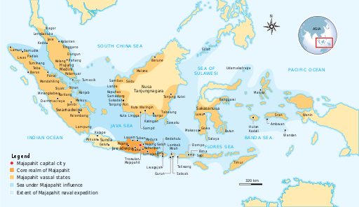
File:Majapahit Empire.svg

此SVG文件的PNG预览的大小:512 × 297像素。 其他分辨率:320 × 186像素 | 640 × 371像素 | 1,024 × 594像素 | 1,280 × 743像素 | 2,560 × 1,485像素。
原始文件 (SVG文件,尺寸为512 × 297像素,文件大小:524 KB)
文件历史
点击某个日期/时间查看对应时刻的文件。
| 日期/时间 | 缩略图 | 大小 | 用户 | 备注 | |
|---|---|---|---|---|---|
| 当前 | 2016年10月28日 (五) 13:07 |  | 512 × 297(524 KB) | Gunkarta | Correction on Luwu location |
| 2009年11月5日 (四) 10:13 |  | 781 × 457(525 KB) | Gunkarta | Corrected the location of Malano in northeast coast of Borneo and Wanin/Onin in Papua (today Fak-fak). | |
| 2009年8月10日 (一) 15:43 |  | 781 × 457(525 KB) | Gunkarta | Crop the map again | |
| 2009年8月10日 (一) 15:37 |  | 781 × 463(529 KB) | Gunkarta | Crop the map | |
| 2009年8月10日 (一) 15:27 |  | 986 × 610(582 KB) | Gunkarta | {{Information |Description={{en|1=The Nusantara Archipelago during the height of Majapahit Empire in XIV century. 1. The red dot is Trowulan; Majapahit capital city 2. The dark orange area is core realm of Majapahit on eastern part of Java 3. The light o |
文件用途
以下页面使用本文件:
全域文件用途
以下其他wiki使用此文件:
- ar.wikipedia.org上的用途
- arz.wikipedia.org上的用途
- ast.wikipedia.org上的用途
- ba.wikipedia.org上的用途
- bcl.wikipedia.org上的用途
- bg.wikipedia.org上的用途
- bn.wikipedia.org上的用途
- ca.wikipedia.org上的用途
- cs.wikipedia.org上的用途
- de.wikipedia.org上的用途
- en-two.iwiki.icu上的用途
- eo.wikipedia.org上的用途
- eu.wikipedia.org上的用途
- fa.wikipedia.org上的用途
- fi.wikipedia.org上的用途
- fr.wikipedia.org上的用途
- gl.wikipedia.org上的用途
- he.wikipedia.org上的用途
- hi.wikipedia.org上的用途
- id.wikipedia.org上的用途
- id.wikisource.org上的用途
- id.wiktionary.org上的用途
- it.wikipedia.org上的用途
- ja-two.iwiki.icu上的用途
- km.wikipedia.org上的用途
- ko.wikipedia.org上的用途
- lt.wikipedia.org上的用途
- min.wikipedia.org上的用途
- ml.wikipedia.org上的用途
- mr.wikipedia.org上的用途
- ms.wikipedia.org上的用途
- mt.wikipedia.org上的用途
- ne.wikipedia.org上的用途
查看此文件的更多全域用途。


