
File:Map of the route of Edward III's chevauchée of 1346.svg

此SVG文件的PNG预览的大小:643 × 600像素。 其他分辨率:257 × 240像素 | 515 × 480像素 | 823 × 768像素 | 1,098 × 1,024像素 | 2,195 × 2,048像素 | 1,059 × 988像素。
原始文件 (SVG文件,尺寸为1,059 × 988像素,文件大小:450 KB)
摘要
| 描述 |
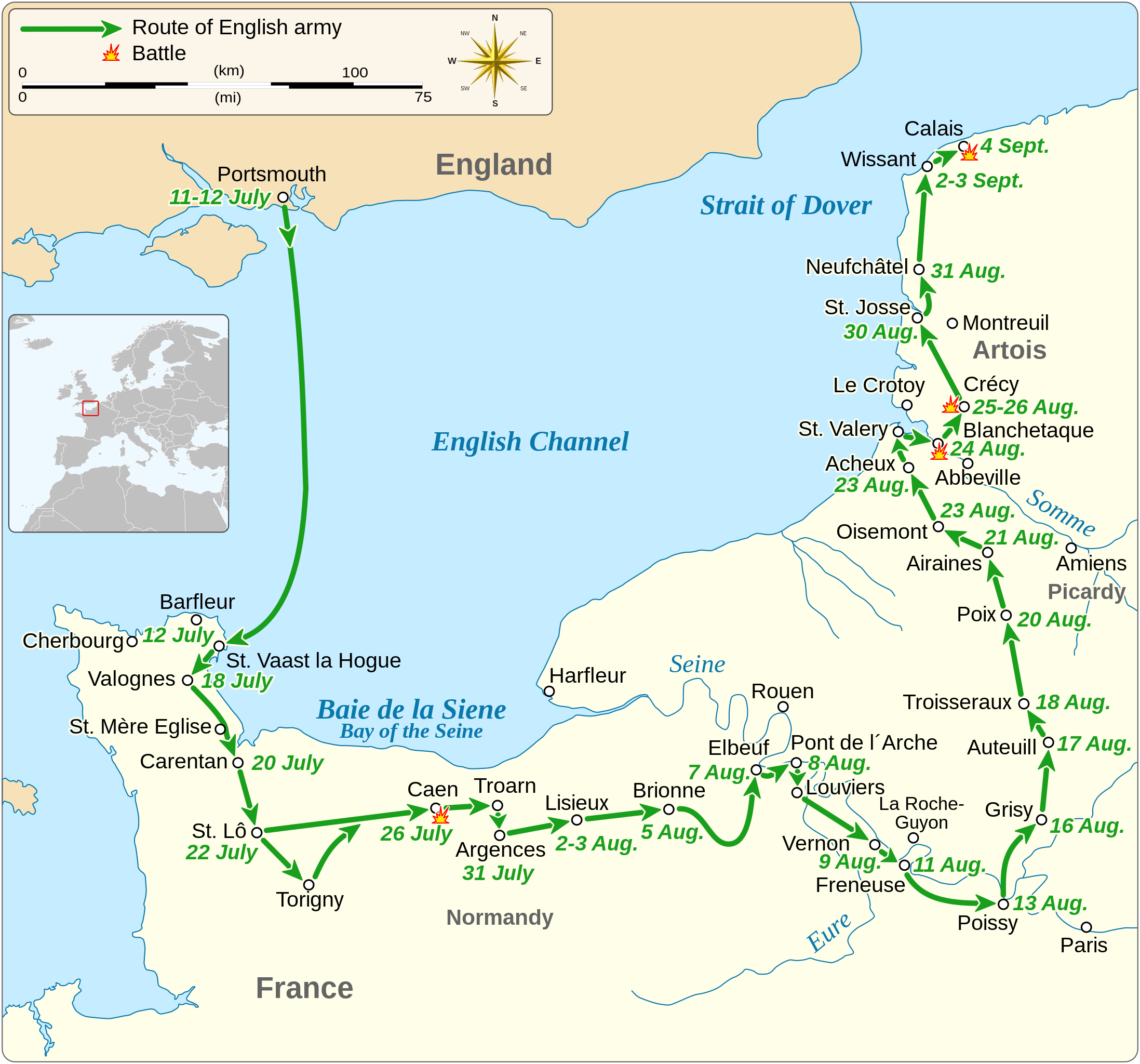
English: Map of the route of Edward III's chevauchée of 1346, part of the Hundred Years' War. This map shows the English army movements during the campaign and the most important battles.
|
|||
| 日期 | ||||
| 来源 |
自己的作品 Derived from; Information from:
|
|||
| 作者 | Goran tek-en | |||
| 授权 (二次使用本文件) |
本文件采用知识共享署名-相同方式共享 4.0 国际许可协议授权。 署名: Goran tek-en
|
|||
| SVG开发 |


| 物体位置 | | 在以下服务上查看本图像和附近其他图像: OpenStreetMap |
|---|


文件历史
点击某个日期/时间查看对应时刻的文件。
| 日期/时间 | 缩略图 | 大小 | 用户 | 备注 | |
|---|---|---|---|---|---|
| 当前 | 2022年2月3日 (四) 00:14 | | 1,059 × 988(450 KB) | Iso10970 | Reverted to version as of 13:17, 9 November 2021 (UTC) |
| 2022年2月3日 (四) 00:13 |  | 1,059 × 988(614 KB) | Iso10970 | File uploaded using svgtranslate tool (https://svgtranslate.toolforge.org/). Added translation for ja. | |
| 2021年11月9日 (二) 13:17 |  | 1,059 × 988(450 KB) | Goran tek-en | Changed view box, font size, added location map | |
| 2019年4月14日 (日) 13:06 |  | 1,059 × 988(191 KB) | Goran tek-en | Spelling | |
| 2019年3月10日 (日) 17:53 |  | 1,059 × 988(115 KB) | JoKalliauer | phab:T36947 bad character aligment on same sizes | |
| 2019年3月6日 (三) 14:08 |  | 1,059 × 988(191 KB) | Goran tek-en | {{Information |description ={{en|1=Map of the route of Edward III's chevauchée of 1346, part of the Hundred Years' War. This map shows the English army movements during the campaign and the most important battles.}} |date =20190306 |source ={{Own}}<br> Derived from; * [https://www.openstreetmap.org/#map=8/49.919/1.371 OSM] Information from: * [https://www.themaparchive.com/the-crecy-campaign-12-july-to-4-september-1346.html themaparchive.com] * {{U|Newm30}} |author... |
文件用途
以下2个页面使用本文件:
全域文件用途
以下其他wiki使用此文件:
- cs.wikipedia.org上的用途
- en-two.iwiki.icu上的用途
- es.wikipedia.org上的用途
- fi.wikipedia.org上的用途
- fr.wikipedia.org上的用途
- hu.wikipedia.org上的用途
- ja-two.iwiki.icu上的用途
- nl.wikipedia.org上的用途
- pt.wikipedia.org上的用途
- ru.wikipedia.org上的用途
- sh.wikipedia.org上的用途
- tr.wikipedia.org上的用途