
File:2012 Olympic Park viewed over Stratford Station from the roof of The Stratford Centre - geograph.org.uk - 1128399.jpg
此為最大尺寸。
2012_Olympic_Park_viewed_over_Stratford_Station_from_the_roof_of_The_Stratford_Centre_-_geograph.org.uk_-_1128399.jpg (640 × 430 像素,檔案大小:69 KB,MIME 類型:image/jpeg)
摘要
| 描述 |
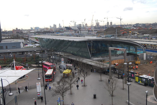
English: 2012 Olympic Park viewed over Stratford Station from the roof of The Stratford Centre Stratford is a major transport hub in East London. Several overground lines including the cross London line to Richmond pass through here, as well as the Jubilee underground line & DLR. There is also a Channel tunnel link & a bus station outside. This view will change dramatically over the next 3 years. |
| 日期 | 攝於2009年1月20日 |
| 來源 | From geograph.org.uk |
| 作者 | Nigel Chadwick |
| 拍攝地點 | | 位於此地的本圖片與其他圖片: OpenStreetMap |
|---|
_heading:247.00&language=zh-tw)
| 目標地點 | | 位於此地的本圖片與其他圖片: OpenStreetMap |
|---|
_heading:247.00&language=zh-tw)
授權條款

|
此圖像來自Geograph工程圖集。攝影師的聯繫資訊請見Geograph網站上該照片的頁面。此圖像的著作權人為Nigel Chadwick,採用創用CC 署名-相同方式共享 2.0許可協議授權二次使用。
|
此檔案採用創用CC 姓名標示-相同方式分享 2.0 通用版授權條款。
姓名標示: Nigel Chadwick
- 您可以自由:
- 分享 – 複製、發佈和傳播本作品
- 重新修改 – 創作演繹作品
- 惟需遵照下列條件:
- 姓名標示 – 您必須指名出正確的製作者,和提供授權條款的連結,以及表示是否有對內容上做出變更。您可以用任何合理的方式來行動,但不得以任何方式表明授權條款是對您許可或是由您所使用。
- 相同方式分享 – 如果您利用本素材進行再混合、轉換或創作,您必須基於如同原先的相同或兼容的條款,來分布您的貢獻成品。
檔案歷史
點選日期/時間以檢視該時間的檔案版本。
| 日期/時間 | 縮圖 | 尺寸 | 使用者 | 備註 | |
|---|---|---|---|---|---|
| 目前 | 2011年2月24日 (四) 23:43 | | 640 × 430(69 KB) | GeographBot | == {{int:filedesc}} == {{Information |description={{en|1=2012 Olympic Park viewed over Stratford Station from the roof of The Stratford Centre Stratford is a major transport hub in East London. Several overground lines including the cross London line to R |
檔案用途
下列3個頁面有用到此檔案:
全域檔案使用狀況
以下其他 wiki 使用了這個檔案:
- bn.wikipedia.org 的使用狀況
- en-two.iwiki.icu 的使用狀況
- Template:Infobox London station
- User talk:Arriva436
- Template:Infobox London station/doc
- User talk:Hyper3
- User talk:Sunil060902
- User talk:Dennisman
- List of busiest railway stations in Great Britain (2021–22)
- User talk:OllieFury
- User talk:Malpass93/Archive
- User talk:Geordiewomble
- User talk:BigToe7000
- User talk:Iridescent/Archive 16
- User talk:DisillusionedBitterAndKnackered/Archive 2
- Wikipedia:WikiProject London Transport/The Metropolitan/Issue 44
- User talk:Matthewedwards/Archives/2012/08
- Template:Infobox London station/sandbox
- User talk:Thryduulf/archive10
- User talk:Fungbregas/Archive 2
- User talk:Simply south/April to December 2012 archive
- User talk:CrossHouses/Archive 1
- User talk:NEWSLETTERS MAILBOX/Archives/2012/August
- User talk:Likelife/Archive 2
- User talk:Alarics/Archive 2012
- User talk:Huangcjz/Archive 1
- List of busiest railway stations in Great Britain (2020–21)
- List of busiest railway stations in Great Britain (2019–20)
- List of busiest railway stations in Great Britain
- fr.wikipedia.org 的使用狀況
- hu.wikipedia.org 的使用狀況
- ml.wikipedia.org 的使用狀況
- simple.wikipedia.org 的使用狀況
- te.wikipedia.org 的使用狀況