
File:Desroches 76.png

此為最大尺寸。
Desroches_76.png (392 × 413 像素,檔案大小:291 KB,MIME 類型:image/png)
摘要
| 描述 |
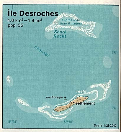
Deutsch: Karte des Desroches-Atolls in den Amiranten, Seychellen
English: Map of Desroches Island (Atoll), Amirantes, Outer Islands of Seychelles
Español: Mapa de Desroches, Archipiélago de Seychelles |
| 日期 | |
| 來源 | http://www.lib.utexas.edu/maps/islands_oceans_poles/ile_desroches_76.jpg |
| 作者 | Taken from Perry-Castañeda Library (PCL), originally from CIA Indian Ocean Atlas |
授權條款
| 本圖像是中央情報局僱員的職務作品。作為美國聯邦政府的作品,本圖像或媒體屬於公有領域。
|

|
原始上傳日誌
Original Uploader was Ratzer (talk) at 20 August 2006.
- 20:05, 20 August 2006 . . Ratzer (Talk | contribs) . . 392×413 (297,762 bytes) (http://www.lib.utexas.edu/maps/islands_oceans_poles/ile_desroches_76.jpg This is a scan from the CIA Indian Ocean Atlas - I just added Desroches Island Resort to it)
檔案歷史
點選日期/時間以檢視該時間的檔案版本。
| 日期/時間 | 縮圖 | 尺寸 | 使用者 | 備註 | |
|---|---|---|---|---|---|
| 目前 | 2007年5月25日 (五) 11:53 | | 392 × 413(291 KB) | Telim tor | == Information == {{Information |Description=Map of Desroches Island (Atoll), Amirantes, Indian Ocean |Source=http://www.lib.utexas.edu/maps/islands_oceans_poles/ile_desroches_76.jpg |Date= |Author=Taken from PCL, originally from CIA Indian Ocean Atlas 19 |
檔案用途
下列頁面有用到此檔案:
全域檔案使用狀況
以下其他 wiki 使用了這個檔案:
- ca.wikipedia.org 的使用狀況
- de.wikipedia.org 的使用狀況
- en-two.iwiki.icu 的使用狀況
- es.wikipedia.org 的使用狀況
- gl.wikipedia.org 的使用狀況
- it.wikipedia.org 的使用狀況
- ka.wikipedia.org 的使用狀況
- nl.wikipedia.org 的使用狀況
- pl.wikipedia.org 的使用狀況
- ru.wikipedia.org 的使用狀況
- uk.wikipedia.org 的使用狀況