
File:ElectoralCollege1796.svg

此 SVG 檔案的 PNG 預覽的大小:542 × 446 像素。 其他解析度:292 × 240 像素 | 583 × 480 像素 | 933 × 768 像素 | 1,245 × 1,024 像素 | 2,489 × 2,048 像素。
原始檔案 (SVG 檔案,表面大小:542 × 446 像素,檔案大小:44 KB)
| U.S. presidential election maps (SVG) |
| See also: National Atlas maps (png) |
|
1789 · 1792 · 1796 · 1800 · 1804 · 1808 · 1812 · 1816 · 1820 · 1824 · 1828 · 1832 · 1836 · 1840 · 1844 · 1848 · 1852 · 1856 · 1860 · 1864 · 1868 · 1872 · 1876 · 1880 · 1884 · 1888 · 1892 · 1896 · 1900 · 1904 · 1908 · 1912 · 1916 · 1920 · 1924 · 1928 · 1932 · 1936 · 1940 · 1944 · 1948 · 1952 · 1956 · 1960 · 1964 · 1968 · 1972 · 1976 · 1980 · 1984 · 1988 · 1992 · 1996 · 2000 · 2004 · 2008 · 2012 · 2016 · 2020 · 2024 |
摘要
| 描述 |
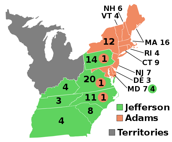
English: 1796 Electoral College |
| 來源 | 自己的作品 |
| 作者 | AndyHogan14 |
| SVG development | W3C-validity not checked. |
授權條款
| 我,此作品的版權所有人,釋出此作品至公共領域。此授權條款在全世界均適用。 這可能在某些國家不合法,如果是的話: 我授予任何人有權利使用此作品於任何用途,除受法律約束外,不受任何限制。 |
檔案歷史
點選日期/時間以檢視該時間的檔案版本。
| 日期/時間 | 縮圖 | 尺寸 | 使用者 | 備註 | |
|---|---|---|---|---|---|
| 目前 | 2020年5月23日 (六) 04:50 | | 542 × 446(44 KB) | Spellcheck | Recreated from 1800 map for consistency Changes: Made District of Columbia a square, Virginia did not get its portion back until 1847. Included western territory of Georgia, which was not ceded until 1802. |
| 2017年1月1日 (日) 19:19 |  | 540 × 443(40 KB) | Wow | MD | |
| 2016年11月14日 (一) 05:52 |  | 540 × 443(40 KB) | Wow | Font and color | |
| 2008年12月31日 (三) 19:43 |  | 540 × 443(31 KB) | AndyHogan14 | {{Information |Description={{en|1=1796 Electoral College}} |Source=Own work |Author=AndyHogan14 |Date= |Permission= |other_versions= }} <!--{{ImageUpload|full}}--> |
檔案用途
下列2個頁面有用到此檔案:
全域檔案使用狀況
以下其他 wiki 使用了這個檔案:
- cs.wikipedia.org 的使用狀況
- da.wikipedia.org 的使用狀況
- de.wikipedia.org 的使用狀況
- el.wikipedia.org 的使用狀況
- en-two.iwiki.icu 的使用狀況
- Thomas Jefferson
- 1796 United States presidential election
- Electoral vote changes between United States presidential elections
- John Adams
- List of United States presidential election results by state
- United States presidential election
- 1796 United States presidential election in Pennsylvania
- 1796 United States elections
- 1796 United States presidential election in Vermont
- 1796 United States presidential election in Connecticut
- 1796 United States presidential election in New York
- 1796 United States presidential election in New Jersey
- 1796 United States presidential election in South Carolina
- Template:State results of the 1796 U.S. presidential election
- 1796 United States presidential election in Virginia
- 1796 United States presidential election in Maryland
- Electoral history of John Adams
- 1796 United States presidential election in Massachusetts
- 1796 United States presidential election in Tennessee
- 1796 United States presidential election in North Carolina
- en.wikibooks.org 的使用狀況
- es.wikipedia.org 的使用狀況
- fa.wikipedia.org 的使用狀況
- fi.wikipedia.org 的使用狀況
- fr.wikipedia.org 的使用狀況
- he.wikipedia.org 的使用狀況
- hu.wikipedia.org 的使用狀況
- it.wikipedia.org 的使用狀況
- ja-two.iwiki.icu 的使用狀況
- ko.wikipedia.org 的使用狀況
- lt.wikipedia.org 的使用狀況
- mk.wikipedia.org 的使用狀況
- nl.wikipedia.org 的使用狀況
- pl.wikipedia.org 的使用狀況
- pt.wikipedia.org 的使用狀況
- ru.wikipedia.org 的使用狀況
檢視此檔案的更多全域使用狀況。