
File:Europe-south-west-kingdoms.png
此為最大尺寸。
Europe-south-west-kingdoms.png (531 × 422 像素,檔案大小:235 KB,MIME 類型:image/png)
摘要
| 描述 |
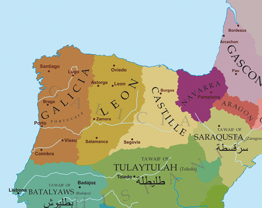
English: Political map of the northwest of the Iberian Peninsula at the end of the 11th century.
Deutsch: Politische Karte des Nordwestens der Iberischen Halbinsel Ende des 11. Jahrhunderts.
Français : Carte politique du nord-ouest de la péninsule ibérique à la fin du XIe siècle.
Galego: Mapa político do noroeste da Península Ibérica a finais do século XI.
Nederlands: Politieke kaart van het noordwesten van het Iberisch schiereiland aan het einde van de 11e eeuw. |
| 日期 | 2009年3月20日 (原始上傳日期) |
| 來源 | Transferred from gl.wikipedia to Commons. |
| 作者 | 原上傳者為加利西亞文維基百科的Alexandre Vigo |
授權條款

|
已授權您依據自由軟體基金會發行的無固定段落、封面文字和封底文字GNU自由文件授權條款1.2版或任意後續版本,對本檔進行複製、傳播和/或修改。該協議的副本列在GNU自由文件授權條款中。 |
| 此檔案採用創用CC 姓名標示-相同方式分享 3.0 未在地化版本授權條款。 | ||
| ||
| 已新增授權條款標題至此檔案,作為GFDL授權更新的一部份。 |
原始上傳日誌
The original description page was here. All following user names refer to gl.wikipedia.
- 2009-03-20 22:59 Alexandre Vigo 531×422× (241008 bytes) Descrición/Description: Mapa político do noroeste da Península Ibérica a finais do século XI. Orixe/Source: Traballo propio. Autor/Author: Atoría propia Copyright: Contido GFDL creado polo que carga o ficheiro. Data/Date: 20/03/09 Outras versións/O
檔案歷史
點選日期/時間以檢視該時間的檔案版本。
| 日期/時間 | 縮圖 | 尺寸 | 使用者 | 備註 | |
|---|---|---|---|---|---|
| 目前 | 2019年1月3日 (四) 20:17 | | 531 × 422(235 KB) | One2 | Reverted to version as of 23:44, 21 March 2009 (UTC). About Alfonso VI: Pope Urban II -> Regi Ildefonso Gallitia, William of Malmesbury -> Gallicae Regie, Orderic Vitalis -> rex Galliciae. |
| 2012年5月13日 (日) 20:54 |  | 531 × 422(264 KB) | Agricolae | remove inaccurate label of Galicia over entire north | |
| 2009年3月21日 (六) 23:44 |  | 531 × 422(235 KB) | Elvire | {{Information |Description={{gl|Mapa político do noroeste da Península Ibérica a finais do século XI.}} {{fr|Carte politique du nord-ouest de la péninsule ibérique à la fin du XI ème siècle.}} |Source=Transferred from [http://gl.wikipedia.org gl. |
檔案用途
下列7個頁面有用到此檔案:
全域檔案使用狀況
以下其他 wiki 使用了這個檔案:
- ar.wikipedia.org 的使用狀況
- azb.wikipedia.org 的使用狀況
- br.wikipedia.org 的使用狀況
- de.wikipedia.org 的使用狀況
- en-two.iwiki.icu 的使用狀況
- es.wikipedia.org 的使用狀況
- fi.wikipedia.org 的使用狀況
- fr.wikipedia.org 的使用狀況
- gl.wikipedia.org 的使用狀況
- id.wikipedia.org 的使用狀況
- it.wikipedia.org 的使用狀況
- ms.wikipedia.org 的使用狀況
- nl.wikipedia.org 的使用狀況
檢視此檔案的更多全域使用狀況。