File:FATAmapPakistan.PNG
外觀

預覽大小:643 × 600 像素。 其他解析度:257 × 240 像素 | 515 × 480 像素 | 806 × 752 像素。
原始檔案 (806 × 752 像素,檔案大小:189 KB,MIME 類型:image/png)
檔案歷史
點選日期/時間以檢視該時間的檔案版本。
| 日期/時間 | 縮圖 | 尺寸 | 使用者 | 備註 | |
|---|---|---|---|---|---|
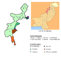
| 目前 | 2010年4月18日 (日) 07:15 |  | 806 × 752(189 KB) | Tianyamm2 | {{Information |Description=Seven agencies of Federally Administered Tribal Areas along with Six frontier regions of F.A.T.A. in Pakistan. 1. Bajaur, 2. Khyber, 3. Kurram, 4. Mohmand, 5. North Waziristan, 6. Orakzai, 7. South Waziristan. |Source=http://en. |
檔案用途
全域檔案使用狀況
以下其他 wiki 使用了這個檔案:
- de.wikipedia.org 的使用狀況
- en-two.iwiki.icu 的使用狀況
- fr.wikipedia.org 的使用狀況
- nn.wikipedia.org 的使用狀況
- simple.wikipedia.org 的使用狀況


