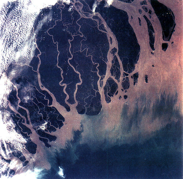
File:Ganges River Delta, Bangladesh, India.jpg
外觀

預覽大小:613 × 600 像素。 其他解析度:245 × 240 像素 | 491 × 480 像素 | 785 × 768 像素 | 1,046 × 1,024 像素 | 1,400 × 1,370 像素。
原始檔案 (1,400 × 1,370 像素,檔案大小:805 KB,MIME 類型:image/jpeg)
檔案歷史
點選日期/時間以檢視該時間的檔案版本。
| 日期/時間 | 縮圖 | 尺寸 | 使用者 | 備註 | |
|---|---|---|---|---|---|
| 目前 | 2005年10月25日 (二) 20:07 |  | 1,400 × 1,370(805 KB) | Brian0918 | GANGES RIVER DELTA, BANGLADESH, INDIA (STS066-92-013). The Ganges River Delta (fig. 5) is the largest inter-tidal delta in the world. With its extensive mangrove mud flats, swamp vegetation and sand dunes, it is characteristic of many tropical and subtr |
檔案用途
下列頁面有用到此檔案:
全域檔案使用狀況
以下其他 wiki 使用了這個檔案:
- ar.wikipedia.org 的使用狀況
- ast.wikipedia.org 的使用狀況
- bh.wikipedia.org 的使用狀況
- bn.wikipedia.org 的使用狀況
- br.wikipedia.org 的使用狀況
- ca.wikipedia.org 的使用狀況
- cs.wikipedia.org 的使用狀況
- cy.wikipedia.org 的使用狀況
- da.wikipedia.org 的使用狀況
- en-two.iwiki.icu 的使用狀況
- Geography of Bangladesh
- River delta
- Geography of West Bengal
- Water politics
- Geology of Bangladesh
- Ganges water dispute
- Portal:Geography/Featured picture/2009, week 39
- Portal:Geography/Featured picture archive/2009
- Outline of geography
- User:Bettymnz4/Geology of Bangladesh
- Flood pulse concept
- User talk:Vsmith/Archive27
- Deltaic lobe
- eo.wikipedia.org 的使用狀況
- es.wikipedia.org 的使用狀況
- et.wikipedia.org 的使用狀況
- eu.wikipedia.org 的使用狀況
- ext.wikipedia.org 的使用狀況
- fr.wikipedia.org 的使用狀況
- gl.wikipedia.org 的使用狀況
- hif.wikipedia.org 的使用狀況
- hi.wikipedia.org 的使用狀況
檢視此檔案的更多全域使用狀況。


