
File:Mandous 2022-12-09 0810Z.jpg

預覽大小:468 × 600 像素。 其他解析度:187 × 240 像素 | 374 × 480 像素 | 599 × 768 像素 | 799 × 1,024 像素 | 1,597 × 2,048 像素 | 3,900 × 5,000 像素。
原始檔案 (3,900 × 5,000 像素,檔案大小:8.94 MB,MIME 類型:image/jpeg)
摘要
| 描述 |
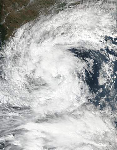
English: This true-color image of Severe Cyclonic Storm Mandous was captured during the afternoon on 9 December 2022, at 1:40 PM (IST) (08:10 UTC), by the Visible Infrared Imaging Radiometer Suite (VIIRS) instrument flying aboard NASA's/NOAA's Suomi-NPP polar-orbiting satellite. Mandous was a fairly strong tropical cyclone and heavy rainmaker that originated from a tropical disturbance by the Andaman Islands during the 2022 North Indian Ocean cyclone season in early December 2022. When this was captured Mandous was over the Bay of Bengal, passing between Sri Lanka and Chennai near its peak intensity as a high-end tropical storm, with winds of 100 km/h (62 mph) (55 knots) on the 1-min Saffir-Simpson scale and winds of 95 km/h (59 mph) (50 knots) on the 3-min IMD cyclone scale making it a "Severe Cyclonic Storm" on that scale, also when this image was taken it had a minimum central pressure of at or around 991 mbar (29.3 inHg). |
| 日期 | |
| 來源 | EOSDIS Worldview |
| 作者 | NASA/Suomi-NPP |
授權條款
本圖像屬於公有領域,因該作品最初來自於美國國家海洋和大氣管理局職員的職務作品。
|
檔案歷史
點選日期/時間以檢視該時間的檔案版本。
| 日期/時間 | 縮圖 | 尺寸 | 使用者 | 備註 | |
|---|---|---|---|---|---|
| 目前 | 2022年12月9日 (五) 14:51 | | 3,900 × 5,000(8.94 MB) | TheWxResearcher | Uploaded a work by NASA/Suomi-NPP from [https://worldview.earthdata.nasa.gov/ EOSDIS Worldview] with UploadWizard |
檔案用途
下列頁面有用到此檔案:
全域檔案使用狀況
以下其他 wiki 使用了這個檔案:
- en-two.iwiki.icu 的使用狀況
- pt.wikipedia.org 的使用狀況
- th.wikipedia.org 的使用狀況
- www.wikidata.org 的使用狀況