
File:Map of the Township of King, Ontario, southern portion, 1878.jpg
預覽大小:800 × 504 像素。 其他解析度:320 × 201 像素 | 640 × 403 像素 | 1,024 × 645 像素 | 1,280 × 806 像素 | 2,560 × 1,612 像素 | 5,379 × 3,387 像素。
原始檔案 (5,379 × 3,387 像素,檔案大小:6.56 MB,MIME 類型:image/jpeg)
| 描述 |
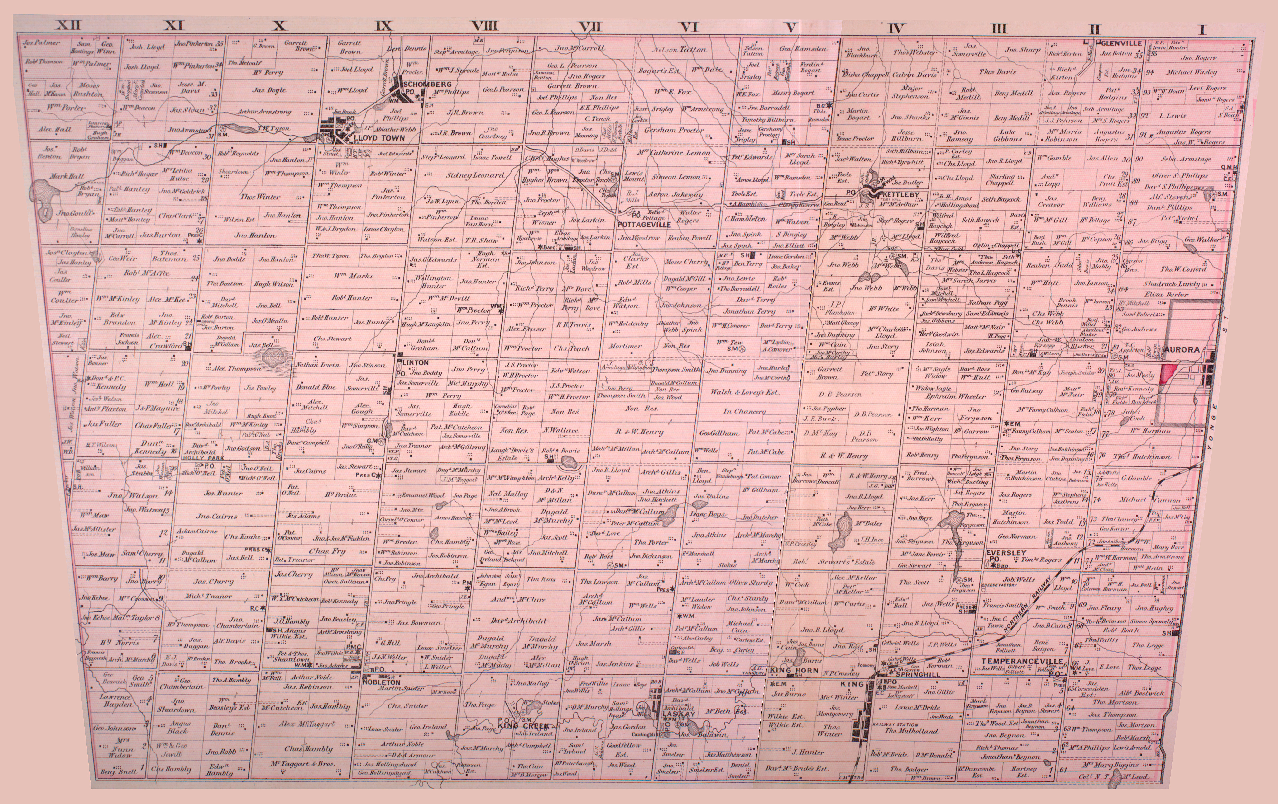
English: Map of Township of King (South), Ontario, part of York County, from 1878. Noted on the map are schoolhouses (SH), post offices (P.O.), Roman Catholic churches (R.C.), Baptist churches (Bap.), Presbyterian churches (PRES or PRESB), and other features. The map shows the boundaries for the township extending to Yonge Street; these lands, represented as lots 61-95, have since been ceded to the towns of Richmond Hill (southern portion), Aurora (central portion) and Newmarket (northern portion, most of which is not shown). |
| 日期 | |
| 來源 | http://digital.library.mcgill.ca/countyatlas/showtownship2.php?townshipid=King+South |
| 作者 | Miles & Co. |
| 其他版本 | The northern portion of the township is shown at File:Map of the Township of King, Ontario, northern portion, 1878.jpg |
此加拿大作品於加拿大屬公有領域,蓋其版權因下列其中一個理由而已經失效︰
本非皇家版權圖像,並且
|
 |
檔案歷史
點選日期/時間以檢視該時間的檔案版本。
| 日期/時間 | 縮圖 | 尺寸 | 使用者 | 備註 | |
|---|---|---|---|---|---|
| 目前 | 2009年4月13日 (一) 16:35 | | 5,379 × 3,387(6.56 MB) | Mindmatrix | {{Information |Description={{en|1=Map of Township of King South, Ontario, part of York County, from 1878. Noted on the map are schoolhouses (SH), post offices (P.O.), Roman Catholic churches (R.C.), Baptist churches (Bap.), Presbyterian churches (PRES or |
檔案用途
下列頁面有用到此檔案:
全域檔案使用狀況
以下其他 wiki 使用了這個檔案:
- en-two.iwiki.icu 的使用狀況