
File:Mars moho topography (MOLA dataset).png

預覽大小:800 × 361 像素。 其他解析度:320 × 144 像素 | 640 × 289 像素 | 1,024 × 462 像素 | 1,280 × 578 像素 | 2,880 × 1,300 像素。
原始檔案 (2,880 × 1,300 像素,檔案大小:1.74 MB,MIME 類型:image/png)
.png?uselang=zh-tw)
.png?uselang=zh-tw)
.png?action=history&uselang=zh-tw)
.png)
摘要
| 描述 |
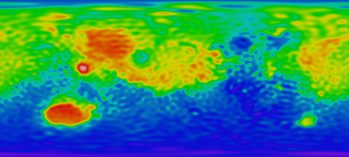
English: Mars Mantle (MOHO) Topography Map. Red means high area and blue means low area, which reveals that the crust in red area is relatively thin and the crust in blue area thick, taking surface topography into consideration.
|
| 日期 | |
| 來源 |
http://svs.gsfc.nasa.gov/stories/MOLA/ http://svs.gsfc.nasa.gov/vis/a000000/a001000/a001092/high_res_flat_moho.tif |
| 作者 |
NASA - Goddard Space Flight Center Scientific Visualization Studio Television Production NASA-TV/GSFC The MOLA Instrument and Science Team |
| 其他版本 |
.png) .png) |
授權條款
| 本作品由NASA創作,屬於公有領域。根據NASA的版權政策:“NASA的創作除非另有聲明否則不受版權保護。”(參見:Template:PD-USGov/zh,NASA版權政策或JPL圖像使用政策) | ||
 |
警告:
|
檔案歷史
點選日期/時間以檢視該時間的檔案版本。
| 日期/時間 | 縮圖 | 尺寸 | 使用者 | 備註 | |
|---|---|---|---|---|---|
| 目前 | 2010年2月4日 (四) 05:20 | | 2,880 × 1,300(1.74 MB) | Areong | {{Information |Description={{en|1=Mars Mantle (MOHO) Topography Map. Red means high area and blue means low area, which reveals that the crust in red area is relatively thin and the crust in blue area thick, taking surface topography into concern. It is |
檔案用途
下列頁面有用到此檔案:
全域檔案使用狀況
以下其他 wiki 使用了這個檔案:
- fr.wikipedia.org 的使用狀況
- fr.wikibooks.org 的使用狀況
.png)