
File:PIA19080-MarsRoverCuriosity-AncientGaleLake-Simulated-20141208.jpg

原始檔案 (2,560 × 1,600 像素,檔案大小:1.05 MB,MIME 類型:image/jpeg)
摘要
| 描述 |
English: December 8, 2014
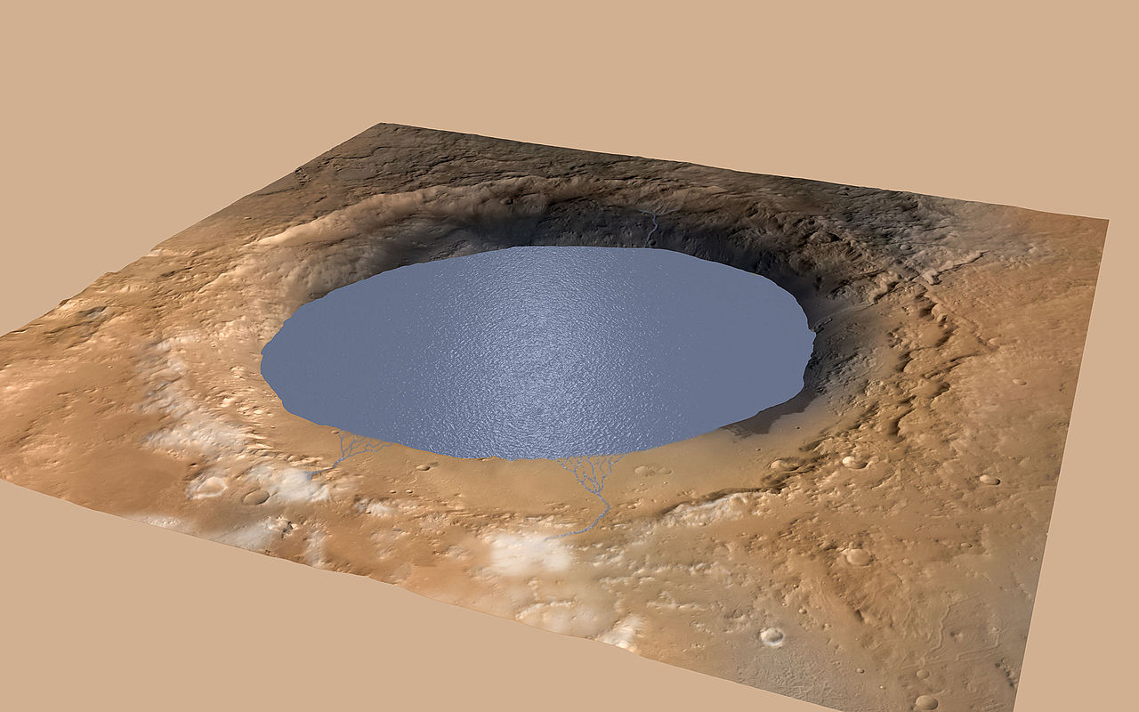
Simulated View of Gale Crater Lake on Mars http://mars.jpl.nasa.gov/msl/multimedia/images/?ImageID=6875 This simulation depicts a lake partially filling Mars' Gale Crater, receiving runoff from snow melting on the crater's rim. Evidence that NASA's Curiosity rover has found of ancient streams, deltas and lakes suggests the crater held a lake such as this more than three billion years ago. This illustration depicts a lake of water partially filling Mars' Gale Crater, receiving runoff from snow melting on the crater's northern rim. Evidence of ancient streams, deltas and lakes that NASA's Curiosity Mars rover mission has found in the patterns of sedimentary deposits in Gale Crater suggests the crater held a lake such as this more than three billion years ago, filling and drying in multiple cycles over tens of millions of years. Gale Crater is 96 miles (154 kilometers) in diameter. This view is looking toward the southeast. The land surface in this illustration is the area's modern shape. Three billion years ago, the rim would have been higher and less eroded. A large layered mountain, Mount Sharp, now stands in the middle of Gale Crater. Accumulation of sediments in lakes, deltas, streams and wind-blown deposits is proposed to have formed the layers making up the lower portion of the mountain. When the crater first held a lake, it might have had central peak, much smaller than Mount Sharp, formed as a rebound from the impact that excavated the crater. Such a peak might have appeared as an island in the lake. This illustration incorporates portions of a simulated oblique view of Gale Crater (http://photojournal.jpl.nasa.gov/catalog/PIA15292) based on elevation data from the High Resolution Stereo Camera on the European Space Agency's Mars Express orbiter, image data from the Context Camera on NASA's Mars Reconnaissance Orbiter, and color information from Viking Orbiter imagery. The appearance of snow is added as part of the simulation of conditions from billions of years ago. The lake is depicted filling the crater approximately to the elevation where Curiosity found lakebed sediments in the "Pahrump Hills" outcrop at the base of Mount Sharp. For more information about the Mars Science Laboratory mission and the mission's Curiosity rover, visit http://www.nasa.gov/msl and http://mars.nasa.gov/msl/. |
| 日期 | |
| 來源 | http://mars.jpl.nasa.gov/msl/images/mars-rover-curiosity-Meyer-Vasavada-Gale-Lake-pia19080-full.jpg |
| 作者 | NASA/JPL-Caltech/ESA/DLR/FU Berlin/MSSS |
授權條款
| 本作品由NASA創作,屬於公有領域。根據NASA的版權政策:“NASA的創作除非另有聲明否則不受版權保護。”(參見:Template:PD-USGov/zh,NASA版權政策或JPL圖像使用政策) | ||
 |
警告:
|
檔案歷史
點選日期/時間以檢視該時間的檔案版本。
| 日期/時間 | 縮圖 | 尺寸 | 使用者 | 備註 | |
|---|---|---|---|---|---|
| 目前 | 2014年12月15日 (一) 20:24 | | 2,560 × 1,600(1.05 MB) | Drbogdan | User created page with UploadWizard |
檔案用途
下列頁面有用到此檔案:
全域檔案使用狀況
以下其他 wiki 使用了這個檔案:
- el.wikipedia.org 的使用狀況
- en-two.iwiki.icu 的使用狀況
- en.wikinews.org 的使用狀況
- es.wikipedia.org 的使用狀況
- it.wikipedia.org 的使用狀況
- ja-two.iwiki.icu 的使用狀況
- pnb.wikipedia.org 的使用狀況
- tr.wikipedia.org 的使用狀況
- uk.wikipedia.org 的使用狀況
- ur.wikipedia.org 的使用狀況