
File:Watkins Glen International Track Map.svg

此 SVG 檔案的 PNG 預覽的大小:450 × 229 像素。 其他解析度:320 × 163 像素 | 640 × 326 像素 | 1,024 × 521 像素 | 1,280 × 651 像素 | 2,560 × 1,303 像素。
原始檔案 (SVG 檔案,表面大小:450 × 229 像素,檔案大小:60 KB)
摘要
| 描述 |
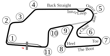
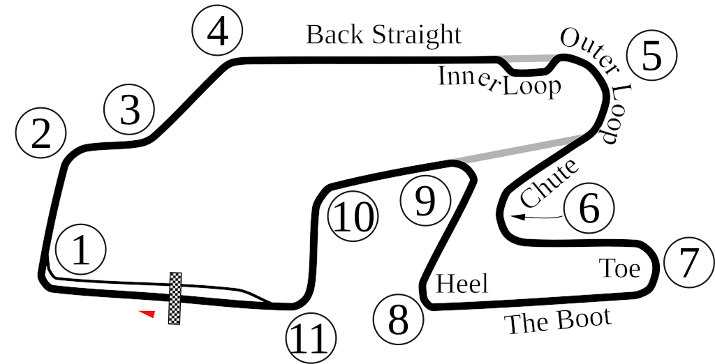
English: Vectorized old version of Image:Watkins Glen International Circuit Map.png. New version also adds the bus stop. |
| 日期 | 6-5-2008 |
| 來源 | 自己的作品 |
| 作者 | Will Pittenger |
| 其他版本 |
 |
| 拍攝地點 | | 位於此地的本圖片與其他圖片: OpenStreetMap |
|---|
授權條款
| 我,此作品的版權所有人,釋出此作品至公共領域。此授權條款在全世界均適用。 這可能在某些國家不合法,如果是的話: 我授予任何人有權利使用此作品於任何用途,除受法律約束外,不受任何限制。 |
檔案歷史
點選日期/時間以檢視該時間的檔案版本。
| 日期/時間 | 縮圖 | 尺寸 | 使用者 | 備註 | |
|---|---|---|---|---|---|
| 目前 | 2009年10月15日 (四) 22:33 | | 450 × 229(60 KB) | Spyder Monkey | Corrected corner numbers, converted text into paths for thumbnail display |
| 2009年10月15日 (四) 22:26 |  | 450 × 229(37 KB) | Spyder Monkey | corrected corner names (inner loop, outer loop); added "Heel" of the boot | |
| 2008年6月6日 (五) 05:29 |  | 450 × 229(77 KB) | Will Pittenger | Updated version that displays the text on paths that were supposed to be there. If you need to edit that text, please edit the older version. | |
| 2008年6月6日 (五) 05:22 |  | 450 × 229(36 KB) | Will Pittenger | {{Information |Description={{en|1=Vectorized old version of Image:Watkins Glen International Circuit Map.png. New version also adds the bus stop.}} |Source=Own work by uploader |Author=Will Pittenger |Date=6-5-2008 |Permissio |
檔案用途
下列頁面有用到此檔案:
全域檔案使用狀況
以下其他 wiki 使用了這個檔案:
- af.wikipedia.org 的使用狀況
- ast.wikipedia.org 的使用狀況
- bn.wikipedia.org 的使用狀況
- de.wikipedia.org 的使用狀況
- en-two.iwiki.icu 的使用狀況
- Watkins Glen International
- 1999 FIA GT Watkins Glen 3 Hours
- 2007 Camping World Watkins Glen Grand Prix
- 6 Hours of Watkins Glen
- 2008 Camping World Indy Grand Prix at the Glen
- 2009 Camping World Grand Prix at the Glen
- List of IMSA GT Championship circuits
- 2009 Six Hours of Watkins Glen
- 2009 Crown Royal 200 at the Glen
- List of IndyCar Series racetracks
- Crown Royal 200 at the Glen
- 2010 Camping World Grand Prix at The Glen
- List of GT World Challenge America circuits
- 2016 IndyCar Grand Prix at The Glen
- 2017 IndyCar Grand Prix at The Glen
- List of IMSA SportsCar Championship circuits
- 2019 6 Hours of The Glen
- 2017 6 Hours of The Glen
- 2021 6 Hours of The Glen
- 2021 WeatherTech 240 at The Glen
- 2022 Sahlen's Six Hours of The Glen
- 2018 6 Hours of The Glen
- 2023 Sahlen's Six Hours of The Glen
- es.wikipedia.org 的使用狀況
- eu.wikipedia.org 的使用狀況
- fa.wikipedia.org 的使用狀況
- fi.wikipedia.org 的使用狀況
- fr.wikipedia.org 的使用狀況
- hr.wikipedia.org 的使用狀況
- hu.wikipedia.org 的使用狀況
- id.wikipedia.org 的使用狀況
檢視此檔案的更多全域使用狀況。