
File:Rabe Crater topography ESA310888.tiff

此TIF文件的PNG预览的大小:800 × 449像素。 其他分辨率:320 × 179像素 | 640 × 359像素 | 1,024 × 574像素 | 1,280 × 718像素 | 2,560 × 1,436像素 | 5,000 × 2,804像素。
原始文件 (5,000 × 2,804像素,文件大小:32.5 MB,MIME类型:image/tiff)
摘要
| 描述 |
English: Colour-coded topography map of Rabe crater and its immediate surroundings. White and red show the highest terrains, while blue and purple show the deepest. The image is based on a digital terrain model of the region, from which the topography of the landscape has been derived.
The image was created using data acquired with the High Resolution Stereo Camera on Mars Express on 7 December 2005 (orbit 2441) and 9 January 2014 (orbit 12736). The scene is located at 35°E/44°S, about 320 km west of the giant Hellas impact basin in the southern highlands of Mars. The image resolution is about 15 m per pixel. |
| 日期 | |
| 来源 | http://www.esa.int/spaceinimages/Images/2014/05/Rabe_Crater_topography |
| 作者 | European Space Agency |
| 授权 (二次使用本文件) |
ESA/DLR/FU Berlin,CC BY-SA 3.0 IGO |
| 其他版本 |
|
| Title | Rabe Crater topography |
| Mission | Mars Express |
| Activity | Space Science |

许可协议
本文件采用知识共享署名-相同方式共享 3.0 政府间组织许可协议授权。
署名: ESA/DLR/FU Berlin
- 您可以自由地:
- 共享 – 复制、发行并传播本作品
- 修改 – 改编作品
- 惟须遵守下列条件:
- 署名 – 您必须对作品进行署名,提供授权条款的链接,并说明是否对原始内容进行了更改。您可以用任何合理的方式来署名,但不得以任何方式表明许可人认可您或您的使用。
- 相同方式共享 – 如果您再混合、转换或者基于本作品进行创作,您必须以与原先许可协议相同或相兼容的许可协议分发您贡献的作品。
文件历史
点击某个日期/时间查看对应时刻的文件。
| 日期/时间 | 缩略图 | 大小 | 用户 | 备注 | |
|---|---|---|---|---|---|
| 当前 | 2017年5月24日 (三) 09:51 | 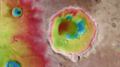 | 5,000 × 2,804(32.5 MB) | Fæ | European Space Agency, Id 310888, http://www.esa.int/spaceinimages/Images/2014/05/Rabe_Crater_topography, User:Fæ/Project_list/ESA |
文件用途
以下页面使用本文件: