干涉合成孔径雷达
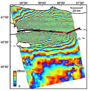
干涉合成孔径雷达(英语:Interferometric synthetic aperture radar,缩写:InSAR或IfSAR)是一种应用于测绘和遥感的雷达技术。这种测量方法使用两幅或多幅合成孔径雷达影像图,根据卫星或飞机接收到的回波的相位差来生成数字高程模型或者地表形变图。[1][2][3]理论上此技术可以测量数日或数年间厘米级的地表形变,可以用于自然灾害监测,例如地震、火山和滑坡,以及结构工程尤其是沉降监测和结构稳定性。

技术
[编辑]合成孔径雷达
[编辑]
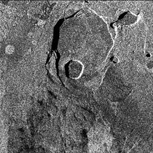
合成孔径雷达(SAR)是一种雷达形式,其中雷达数据的复杂处理用于产生非常窄的有效波束。 它可以用来形成相对固定目标的图像; 移动目标可以在形成的图像中模糊或移位。 SAR是主动遥感的一种形式:天线传输从图像区域反射的辐射,而不是被动传感(反射是从环境照明中检测到的)。 因此,SAR图像采集与自然照明无关,并且可以在夜间拍摄图像。 雷达使用微波频率的电磁辐射; 典型雷达波长的大气吸收非常低,这意味着云层不会阻止观测。
相位
[编辑]影响相位的因素
[编辑]InSAR的难点
[编辑]生成干涉图
[编辑]软件
[编辑]有许多InSAR处理软件可供使用,其中有些对于学术用途是免费的。
- GMTSAR - 是完全开源的InSAR处理软件,主要使用c写成,由cshell串联,使用地理绘图软件GMT生成结果。Github主页[1] (页面存档备份,存于互联网档案馆)
- IMAGINE InSAR - 是ERDAS IMAGINE遥感套件所包含的InSAR处理包,用C++写成。主页是[2] (页面存档备份,存于互联网档案馆) 。
- ROI PAC - 由NASA的喷气推进实验室和Caltech开发。运行于UNIX,可以在The Open Channel Foundation免费下载。
- DORIS - Delft University of Technology开发的处理套件,C++写成,一直到多个平台,基于GPL许可证发布:DORIS[永久失效链接]。
- Gamma Software - 商业套件,拥有多个模块覆盖了SAR数据处理、SAR干涉、差分SAR干涉等。运行于Solaris、Linux、Mac OS和Windows,研究机构可获得大幅度的折扣[3] (页面存档备份,存于互联网档案馆)。
- SARscape - 商业套件,拥有多个模块覆盖了SAR数据处理、SAR干涉、差分SAR干涉等。作为ArcView和ENVI的扩展运行于Windows、Linux和Mac OS下[4] (页面存档备份,存于互联网档案馆)。
- Pulsar - 商业套件,基于UNIX[5] (页面存档备份,存于互联网档案馆)。
- DIAPASON - 法国空间局CNES开发,[4][5]由Altamira Information维护,商业套件。运行于UNIX和Windows[6]。
- SAR Studio -商业套件,由迅感科技(北京)有限公司开发[7] (页面存档备份,存于互联网档案馆),拥有多项核心技术、支持多种SAR卫星传感器,具备强大的SAR处理能力,提供150余个联合开发商业级算法模块,已成为一款综合、可靠、高效的商业化地形高程反演和地表形变监测软件系统。
- Skysense-InSAR - 商业套件,由洪都天顺(深圳)科技有限公司开发,依托香港中文大学太空所研发团队,运行于Windows,主页是[6]
数据源
[编辑]应用
[编辑]构造
[编辑]InSAR可应用于构造形变,例如地震造成的地表位移。首次应用实在1992年Landers地震[4],很快便在全球各种地震之中普遍使用,特别是对1999年土耳其伊兹密特和2003年伊朗巴姆地震进行了深入研究。[7] [8] InSAR也可用于监测断层。
火山监测
[编辑]InSAR被用于各种火山监测,包括爆发造成的形变,爆发中深层岩浆分布的变化造成的地表应变,火山体的重力延展,和火山构造形变信号。[9]早期基于InSAR的火山研究对象包括埃特纳火山,[5]和基拉韦厄峰,[10]随着此领域的发展,更多的火山研究开始进行。尽管此技术作为可行的火山监测技术存在各种限制,例如卫星的重现时间、档案数据的缺乏、相干性和大气误差,但它仍然广泛应用于火山形变的学术研究。[11]最近,InSAR也被应用于埃塞俄比亚的峡谷研究。[12]
地面沉降
[编辑]DEM生成
[编辑]永久散射体
[编辑]永久或固定不变的散射体技术相对传统InSAR来说是最近开发的,它基于对一些列干涉图中保持相干性像素的研究。1999年,意大利米兰理工大学的研究人员开发了一种新的多图象处理方式,这就是在一摞图像中寻找地面上提供了稳定持久雷达反射的物体。这些物体可以是像素般大,通常是子像素大,出现于每一幅图像中。
米兰理工大学在1999年为此技术申请了专利,并在2000创建了附属公司Tele-Rilevamento Europa - TRE来进行此技术的商业化操作和进一步的研究。
Some research centres and other companies were inspired to develop their own algorithms which would also overcome InSAR's limitations. In scientific literature, these techniques are collectively referred to as Persistent Scatterer Interferometry or PSI techniques. The term Persistent Scatterer Interferometry (PSI) was created by ESA to define the second generation of radar interferometry techniques.
Commonly such techniques are most useful in urban areas with lots of permanent structures, for example the PSI studies of European cities undertaken by the Terrafirma project.[13] The Terrafirma project (led by Fugro NPA) provides a ground motion hazard information service, distributed throughout Europe via national geological surveys and institutions. The objective of this service is to help save lives, improve safety, and reduce economic loss through the use of state-of-the-art PSI information. Over the last 5 years this service has supplied information relating to urban subsidence and uplift, slope stability and landslides, seismic and volcanic deformation, coastlines and flood plains.
引用
[编辑]- ^ Massonnet, D.; Feigl, K. L., Radar interferometry and its application to changes in the earth’s surface, Rev. Geophys. 36 (4), 1998, 36 (4): 441–500, doi:10.1029/97RG03139
- ^ Burgmann, R.; Rosen, P.A.; Fielding, E.J., Synthetic aperture radar interferometry to measure Earth's surface topography and its deformation, Annual Review of Earth and Planetary Sciences 28, 2000, 28: 169–209, doi:10.1146/annurev.earth.28.1.169
- ^ Hanssen, Ramon F., Radar Interferometry: Data Interpretation and Error Analysis, Kluwer Academic, 2001, ISBN 9780792369455
- ^ 4.0 4.1 Massonnet, D.; Rossi, M.; Carmona, C.; Adragna, F.; Peltzer, G.; Feigl, K.; Rabaute, T., The displacement field of the Landers earthquake mapped by radar interferometry, Nature 364, 1993, 364: 138–142, doi:10.1038/364138a0
- ^ 5.0 5.1 Massonnet, D.; Briole, P.; Arnaud, A., Deflation of Mount Etna monitored by spaceborne radar interferometry, Nature 375, 1995, 375: 567–570, doi:10.1038/375567a0
- ^ 洪都天顺(科技)有限公司. [2017-06-19]. (原始内容存档于2018-04-22).
- ^ Envisat's rainbow vision detects ground moving at pace fingernails grow. European Space Agency. August 6, 2004 [2007-03-22]. (原始内容存档于2007-04-12).
- ^ The Izmit Earthquake of 17 August 1999 in Turkey. European Space Agency. [2007-03-22]. (原始内容存档于2007-03-10).
- ^ Wadge, G., A strategy for the observation of volcanism on Earth from space, Phil. Trans. Royal Soc.Lond. 361, 2003, 361: 145–156
- ^ Rosen, P. A.; Hensley, S.; Zebker, H. A.; Webb, F. H.; Fielding, E. J., Surface deformation and coherence measurements of Kilauea Volcano, Hawaii, from SIR C radar interferometry, J. Geophys. Res. 101 (E10), 1996, 101 (E10): 23,109–23,126, doi:10.1029/96JE01459
- ^ Stevens, N.F.; Wadge, G., Towards operational repeat-pass SAR interferometry at active volcanoes, Natural Hazards 33, 2004, 33: 47–76, doi:10.1023/B:NHAZ.0000035005.45346.2b
- ^ Wright, T.J.; Ebinger, C.; Biggs, J.; Ayele, A.; Yirgu, G.; Keir, D.; Stork, A., Magma-maintained rift segmentation at continental rupture in the 2005 Afar dyking episode (PDF), Nature 442, 2006, 442: 291–294 [2009-07-13], doi:10.1038/nature04978, (原始内容存档 (PDF)于2007-01-04)
- ^ Ground movement risks identified by Terrafirma. European Space Agency. 8 September 2006 [2007-03-21]. (原始内容存档于2006-10-05).
参见
[编辑]外部链接
[编辑]- InSAR, a tool for measuring Earth's surface deformation (页面存档备份,存于互联网档案馆) Matthew E. Pritchard
- Radar interferometry tutorial
- USGS InSAR factsheet (页面存档备份,存于互联网档案馆)
- InSAR Principles (页面存档备份,存于互联网档案馆), ESA publication, TM19, February 2007.
- B. Kampes, Radar Interferometry – Persistent Scatterer Technique, Kluwer Academic Publishers, Dordrecht,The Netherlands, 2006. ISBN 978-1402045769
