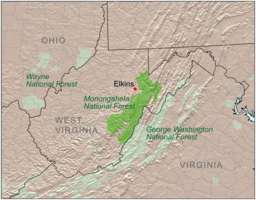
莫農加希拉國家森林
| Monongahela National Forest | |
| 美國國家森林 | |
View from the slopes of Back Allegheny Mountain looking east. Visible are 阿勒格尼山脈 (middle distance) and Shenandoah Mountain (far distance). 遠方是弗吉尼亞州的喬治·華盛頓和傑斐遜國家森林
| |
| 名稱起源:莫農加希拉河,流域的大部分為此原始森林 | |
| 國家 | |
|---|---|
| 省/州/邦 | |
| 縣[1] | 格蘭特縣、格林布賴爾縣、尼古拉斯縣、彭德爾頓縣、波卡洪塔斯縣、普雷斯頓縣、蘭道夫縣、塔克縣、韋伯斯特縣 |
| Ranger Districts[1] | Cheat-Potomac、Greenbrier、Marlinton-White Sulphur Springs、Gauley |
| 最高點 | 斯普魯斯丘 |
| - 位置 | 西弗吉尼亞州彭德爾頓縣 |
| - 海拔 | 4,863 ft(1,482.2 m) |
| 最低點 | 波托馬克河南支 |
| - 位置 | 西弗吉尼亞州Petersburg以西 |
| - 海拔 | 968 ft(295 m) |
| 面積 | 921,150 英畝(372,776 公頃)[2] |
| - Proclamation Boundary | 1,706,898 英畝(690,757 公頃)[2] |
| Established | 1920年4月28日 |
| - Monongahela Purchase | 1915年 |
| 所有者 | 美國國家森林局 |
| IUCN保護區分類 | VI - 資源管理保護區 |
| Headquarters | 西弗吉尼亞州Elkins |
| 網站:Monongahela National Forest | |
莫農加希拉國家森林(英語:Monongahela National Forest)是美國西弗吉尼亞州的一座國家森林,位於阿勒格尼山脈以東[3]。
參考文獻[編輯]
引文[編輯]
- ^ 1.0 1.1 Monongahela National Forest: Land and Resource Management Plan (PDF). Monongahela National Forest. September 2006 [2009-01-19]. (原始內容存檔 (PDF)於2009-01-19).
- ^ 2.0 2.1 Land Areas of the National Forest System (PDF). U.S. Forest Service. January 2012 [June 30, 2012]. (原始內容存檔 (PDF)於2013-01-16).
- ^ About the Forest. Monongahela National Forest. [April 13, 2010]. (原始內容存檔於2012-08-13).
其他來源[編輯]
- 馬金,C.R.(1970), 莫農加希拉的國家森林歷史中,未發表的手稿,可在莫農加希拉的國家森林辦公室, 埃爾金斯,西弗吉尼亞州.
- de Hart,艾倫和布魯Sundquist(2006年)、 莫農加希拉的國家森林裏徒步旅行指南,第8版, 西弗吉尼亞高原的保護, Charleston的,西弗吉尼亞州.
- Berman,Gillian梅斯梅麗莎康利-Spencer,Barbara J.豪爾和夏琳用(1992年)、 莫農加希拉的國家森林:1915-1990,Morgantown、西弗吉尼亞州:西弗吉尼亞公眾的歷史記錄的程序;為聯合國森林服務:莫農加希拉的國家森林。 (March1992)
- DeMeo,湯姆和Julie康坎農(1996年),"在星期一:圖像和物質在西弗吉尼亞州的國家森林"的, 內心的聲音,第一卷。 8時,問題1,January/February.
- 曼德尼(1977年), 經驗教訓,從莫農加希拉的經驗,美國農業部、森林服務。
- 這篇文章中包含的信息,最初來自美國政府出版物和網站,並在公共領域。


