麥基諾城
| 麥基諾城 | |
|---|---|
| 村 | |
| 麥基諾城村 Village of Mackinaw City | |
 麥基諾城旅館區 | |
| 坐標:45°47′02″N 84°43′40″W / 45.78389°N 84.72778°W | |
| 國家 | 美國 |
| 州 | 密歇根州 |
| 縣 | 埃米特縣 和 希博伊根縣 |
| 鎮區 | Mackinaw和Wawatam |
| 面積[1] | |
| • 總計 | 7.65 平方英里(19.83 平方公里) |
| • 陸地 | 3.44 平方英里(8.92 平方公里) |
| • 水域 | 4.21 平方英里(10.91 平方公里) |
| 海拔 | 597 英尺(182 公尺) |
| 人口(2020) | |
| • 總計 | 846人 |
| • 密度 | 245.72人/平方英里(94.88人/平方公里) |
| 網站 | Official website |
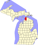
麥基諾城(英語:Mackinaw City)是美國密歇根州的一個村,正式名稱為麥基諾城村(英語:Village of Mackinaw City)。麥基諾城位於麥基諾水道南岸,通過麥基諾大橋連接到密歇根上半島。[2][3][4]
麥基諾城產業主要為旅遊業,根據2020年美國人口普查,共有846人。[5][6]在夏季旅遊旺季,有大量遊客和季節性工人來到該地。[7]麥基諾城行政上隸屬埃米特縣和希博伊根縣,有一座小學(K-5)和一座中學(6-12)。[8]
歷史
[編輯]1715,法國人在該地建造一座木製的米奇利麥基諾堡,為該地第一個歐洲人定居點。[9][10]之後該地先後在法國人、英國人和北美洲原住民之間易手。美國獨立戰爭期間,英國人從該地撤到了附近的麥基諾島上建立堡壘,並將該地的建築都拆除或燒毀。
1857年,人們來到該地重新進行城市規劃。1875年,麥基諾城附近的麥基諾島被規劃為麥基諾國家公園。1890年代起,麥基諾城成為了穿越麥基諾水道的鐵路渡輪的重要港口。1900年代初起,麥基諾城也成為了汽車渡輪的港口,汽車渡輪一直運行到1957年麥基諾大橋開通為止。
如今,麥基諾城的主要產業幾乎完全以旅遊為導向,其他主要就業來源是為郵政、警察、消防、教育等。
交通
[編輯]
公路
[編輯]輪渡
[編輯]有兩家渡輪公司,Shepler's Ferry和Star Line Ferry,提供往返麥基諾島的輪渡服務。
巴士
[編輯]Indian Trails提供每日往返聖伊尼亞斯和東蘭辛、貝城之間的巴士服務,麥基諾城為換乘站點之一。
其他
[編輯]過去曾有北箭列車提供鐵路客運服務。現已廢棄,原路線被開發成徒步小徑North Central State Trail。[11]
最近的機場為埃米特縣的佩爾斯頓地區機場,天西航空每天提供三班出發和三班到達的服務。[12]
氣候
[編輯]| 密歇根州,麥基諾城 | |||||||||||||
|---|---|---|---|---|---|---|---|---|---|---|---|---|---|
| 月份 | 1月 | 2月 | 3月 | 4月 | 5月 | 6月 | 7月 | 8月 | 9月 | 10月 | 11月 | 12月 | 全年 |
| 平均高溫 °C(°F) | −3 (27) |
−1 (31) |
5 (41) |
13 (55) |
20 (68) |
25 (77) |
27 (81) |
26 (79) |
21 (70) |
14 (58) |
7 (44) |
0 (32) |
13 (55) |
| 平均低溫 °C(°F) | −15 (5) |
−15 (5) |
−9 (15) |
−3 (27) |
3 (38) |
8 (47) |
11 (52) |
10 (50) |
6 (42) |
0 (32) |
−4 (24) |
−11 (13) |
−2 (29) |
| 平均降水量 mm(吋) | 46 (1.8) |
33 (1.3) |
53 (2.1) |
58 (2.3) |
64 (2.5) |
84 (3.3) |
86 (3.4) |
97 (3.8) |
89 (3.5) |
61 (2.4) |
56 (2.2) |
48 (1.9) |
770 (30.4) |
| 數據來源:Weatherbase[13] | |||||||||||||
圖片集
[編輯]-
麥基諾角老燈塔
-
麥古平角燈塔
-
從麥基諾市看麥基諾大橋
-
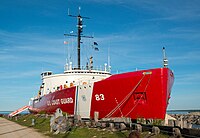
麥基諾市湖岸邊停泊的美國海岸警衛隊前破冰船USCGC Mackinaw (WAGB-83)
-
麥基諾市村內路口
-
麥基諾市Star Line Ferry渡輪碼頭
相關條目
[編輯]參考資料
[編輯]- ^ 2020 U.S. Gazetteer Files. United States Census Bureau. [May 21, 2022]. (原始內容存檔於2022-05-28).
- ^ Government - Village of Mackinaw City. The Village of Mackinaw City. [27 April 2013]. (原始內容存檔於23 May 2013).
- ^ OFFICIAL MACKINAW AREA VISITORS BUREAU. Mackinaw City. [2022-07-14]. (原始內容存檔於2022-07-05).
- ^ Village of Mackinaw City Michigan, USA. Village of Mackinaw City Municipal. [2022-07-14]. (原始內容存檔於2022-07-14).
- ^ Visit Mackina City on the Straits of Mackinac. [2022-07-14]. (原始內容存檔於2022-03-08).
- ^ U.S. Census website. United States Census Bureau. [2022-07-14]. (原始內容存檔於1996-12-27).
- ^ Mackinac Island plays labor lottery as summer workers are hard to find. MLive. [2022-07-14]. (原始內容存檔於2022-07-30).
- ^ 存档副本. [2022-07-14]. (原始內容存檔於2022-07-08).
- ^ http://www.biographi.ca/en/bio/le_marchand_de_lignery_constant_2E.html (頁面存檔備份,存於互聯網檔案館) "In 1712, when war with the Fox Indians broke out and Louvigny found himself unable to leave for the west, Vaudreuil decided to send Lignery at the head of a small party to take possession of the post."
- ^ https://books.google.com/books?id=FaP7AQAAQBAJ&lpg=PT1007&ots=TcmEePh-S4&dq=Constant%20le%20Marchand%20de%20Lignery%20michilimackinac&pg=PT1007#v=onepage&q=Constant%20le%20Marchand%20de%20Lignery%20michilimackinac&f=false (頁面存檔備份,存於互聯網檔案館) "By 1713 the French decided to rebuild the fort at the straits, and in 1715 ... Ligerny arrived with soldiers and workmen." The Americas: International Dictionary of Historic Places edited by Trudy Ring, Noelle Watson, Paul Schellinger; Routledge Press Nov 5, 2013
- ^ North Eastern State Recreation Trail. [February 9, 2015]. (原始內容存檔於2016-10-07).
- ^ 存档副本. [2022-07-14]. (原始內容存檔於2021-12-24).
- ^ Weatherbase.com. Weatherbase. 2013 [2022-07-14]. (原始內容存檔於2016-04-01). Retrieved on August 27, 2013.
外部連結
[編輯] 維基共享資源上的相關多媒體資源:麥基諾城
 英語維基導遊上的相關旅遊指南:Mackinaw City


