
File:NPS jewel-cave-layout-map.pdf

此PDF文件的JPG预览的大小:671 × 599像素。 其他分辨率:269 × 240像素 | 538 × 480像素 | 739 × 660像素。
原始文件 (739 × 660像素,文件大小:7.21 MB,MIME类型:application/pdf)
摘要
| 描述 |
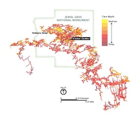
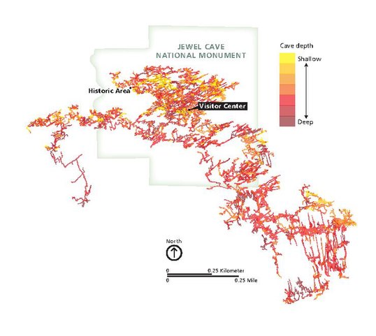
English: Jewel Cave underground map, showing the passageways, tunnels, and chambers that make up the Jewel Cave complex . |
| 日期 | |
| 来源 | U.S. National Park Service (http://npmaps.com/wp-content/uploads/jewel-cave-layout-map.pdf) |
| 作者 | U.S. National Park Service, restoration/cleanup by Matt Holly |
| 其他版本 |
 |
许可协议
| This image or media file contains material based on a work of a National Park Service employee, created as part of that person's official duties. As a work of the U.S. federal government, such work is in the public domain in the United States. See the NPS website and NPS copyright policy for more information. |
文件历史
点击某个日期/时间查看对应时刻的文件。
| 日期/时间 | 缩略图 | 大小 | 用户 | 备注 | |
|---|---|---|---|---|---|
| 当前 | 2017年5月17日 (三) 00:17 |  | 739 × 660(7.21 MB) | RKBot | =={{int:filedesc}}== {{Information |description= {{en|1=Jewel Cave underground map, showing the passageways, tunnels, and chambers that make up the Jewel Cave complex .}} |date= 2016-04-22 |source= U.S. National Park Service (http://npmaps.com/wp-conte... |
文件用途
以下页面使用本文件: